Book of Mormon Geography Found- Mexican Highland Continental Model (summary)
by Lance Weaver
Outline
This article is only a very rough draft summary of a much larger book I’m writing which I don’t expect to finish for at least a decade. The basic outline of this model came to my brother and I in a series of dreams/morning visions and research about 20 years ago shortly after returning from our LDS missions. Since those initial experiences a continual stream of incredibly insights, dreams/visions and ideas have come to me which have helped me unravel and understand parts of this model which not even I believed early on. Since those initial experiences I’ve been through the up and downs of life and have even done my best to lose faith and run from the calling I believe I received to reveal the correct Book of Mormon geographic model and help convince the Natives Americans of Oklahoma, the US Southwest, and West/South-central Mexico of the truth of these ancestral groups of theirs. Ultimately this convincing will be done the same way it was for me–through dreams and visions where ancestors visit their progeny and pass onto them the riches of their heritage through spiritual means.
And it shall come to pass in the last days, saith God, I will pour out of my Spirit upon all flesh: and your sons and your daughters shall prophesy, and your young men shall see visions, and your old men shall dream dreams (Acts 2:17)
For I would not, brethren, that ye should be ignorant of this mystery, lest ye should be wise in your own conceits; that blindness in part is happened to Israel, until the fulness of the Gentiles be come in. (Romans 11:25)
But they shall be gathered again; but they shall remain until the times of the Gentiles be fulfilled. And in that day shall be heard of wars and rumors of wars, and the whole earth shall be in commotion, and men’s hearts shall fail them, and they shall say that Christ delayeth his coming until the end of the earth. (D&C 45:25–26)
- Introduction
- Summery of what sets this model apart.
- Internal Model. (compare a bit to heartland and Mesoamerica)
- The Continental Model of Joseph Smith
- The writings of Ixtlilxochitl
- The Caractors document.
- The Narrow Neck.
- Arrival of the Jaredites (put after Nephites?)
- Omer and his household
- Post Dearth Jaredite culture
- Colonial arrivals (arrival writing, pyramids)
- Olmec or Zapotec as the mother culture? (Emergence of Zapotec hieroglyphic writing and calendrics to Mesoamerica)
- The move the Zarahemla
- The Seven Tribes of Early athors (find quotes) Matching BOM seven tribes.
- Zeniff and the City of Nephi
- Towers AND temple matching so well Noah’s building project.
- The emergence of the Zapotec Military State. (skull racks & warefare)
- Captain Moroni: Fortifying the Balsas Basin & Mexican Highland
- Mixtec sites move to fortresses & garrisons on East Coast.
- The people of Ammon in Jershon, linguistics matching matriarchal society of…
- Could the major Burial of Chiape de Corzo be Lamoni’s father?
- Lachoneous and the Founding of Teotihuacan
- Cataclysms at the coming of Christ
- Ixtextla records. Known volcanism and destruction of towns. PROBLEMS WITH RADIOCARBON DATING. (see txt file ‘anomalous old c14 dates in archaeology papers folder in drive)
- Tetimpa, Cuicuilco and Cholula were covered with volcanic ash like Pompaii right near the time of Christ. Zarahemla of Sorenson or Usamacinta models are 100 miles or more from the single active volcanic center. [make map of mexico’s active volcanoes]
- The tents, houses of cement (adobe) and shipping of timber in the desolate southwest.
- The golden or ‘Classic’ age of Zion
- Was Mormon Anasazi? A case for time discrepancies in 4rth Nephi
- The land of Desolation (matching accounts of Aztlan so well)
- The destruction of American Civilization
.
Introduction
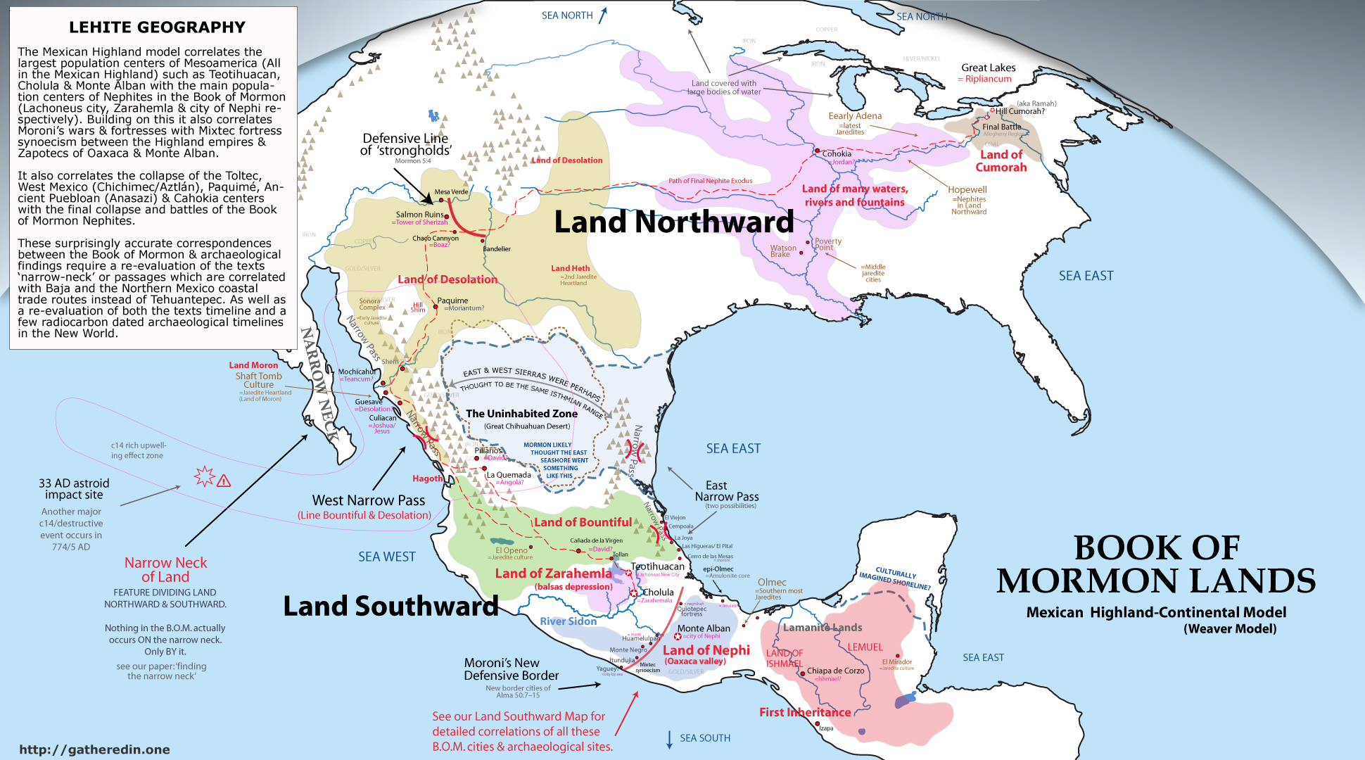
This article presents the new Mexican Highland-continental model Book of Mormon Geographic correlation. With this model, essentially every culture the texts mentions end up being a major culture found by modern archaeologists. In fact, essentially all the largest North American prehistoric cultures are represented in this model of the Book of Mormon text. This unique continental model also correlates incredibly closely to the beliefs of Joseph Smith and other early LDS prophetic figures.
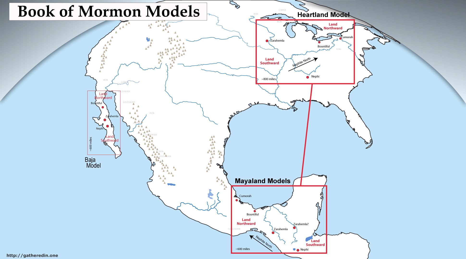
Far from sticking the Book of Mormon location into a small Mesoamerican or Heartland corner, our model correlates the texts most mentioned cities with the most influential Mesoamerican archaeological ruins. Zarahemla and the Nephites are correlated with arguably the largest cities and most dominate, powerful prehistoric culture on the continent — Teotihuacan/Cholula and the Mexican Highland/Balsas Basin culture. The Lamanites are correlated with what was likely the most sophisticated and populous culture in American prehistory — the Maya. The City of Nephi with its towers, priest cult and expensive public works correlates with the great Zapotec fortress of Monte Alban, which sat between the Maya (Lamanite) and Highland (Nephite) cultures. The River Sidon matches with what many consider Mexico’s most economically important & strategic water way– the Rio Balsas.
The book of Mormon’s ‘Land Northward’ stretches from the rock & cement great-houses of the ancient Puebloan peoples in the desert southwest, where Joseph Smith taught “the Nephites lost their power”, all the way through Mississippian and Hopewell peoples of the Eastern United States.
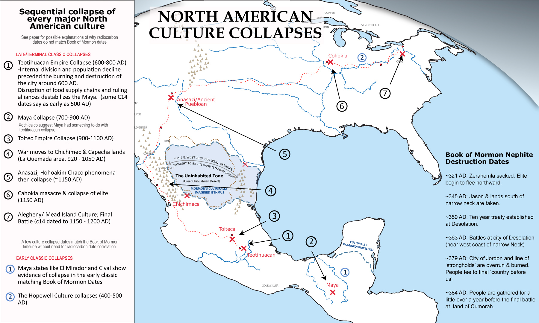
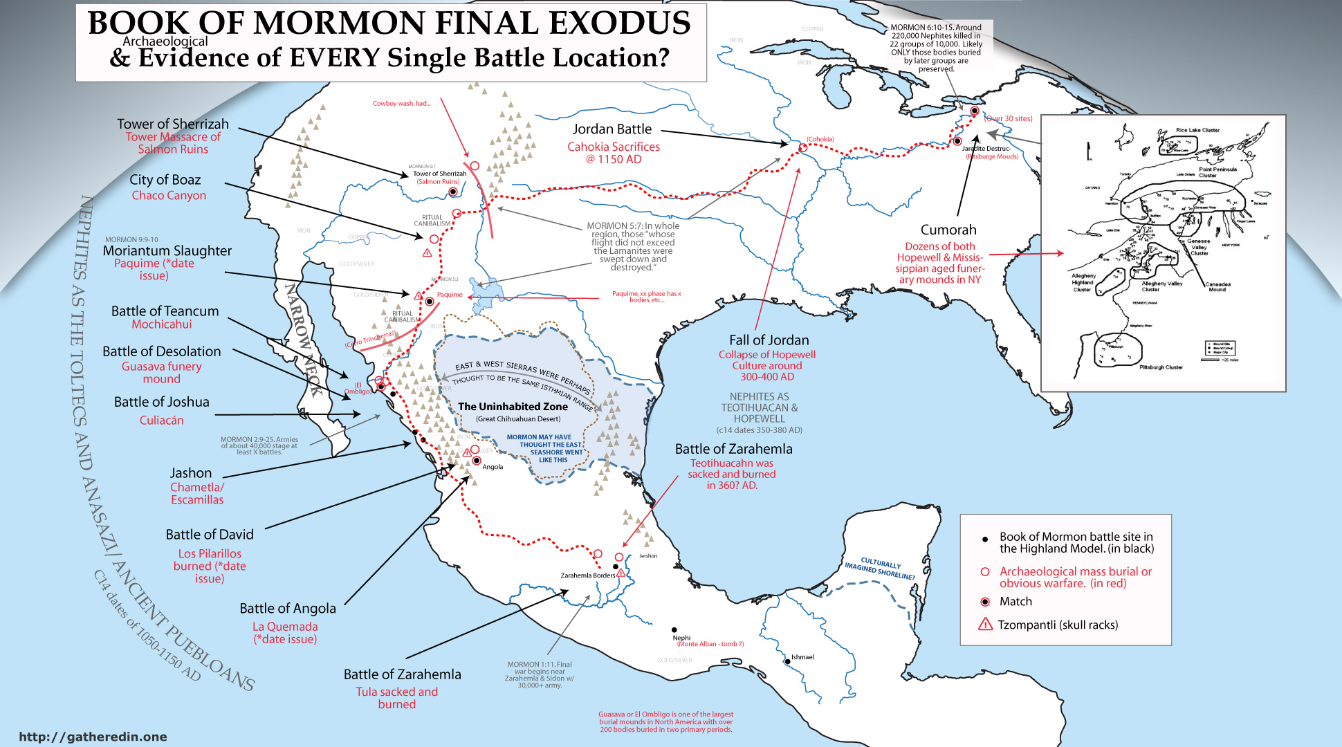
The early Jaredites end up largely corresponding to not only the first inhabitants on the continent but also the only North American culture that archaeologists have found to have coexisted with elephants and other extinct mega-fauna (Paleoindian, Clovis & Folsom cultures). They expanded to cover both Northern America and Mexico instead of just a part of the Isthmus of Tehuantepec (proto-Adena as well as Olmec & all other archaic to early formative/woodland groups). And the destruction of the Nephite culture described in the text, corresponds to the well-known collapse of essentially half the major cultures on the North American continent between the radiocarbon dates of 1050-1150 AD from Tula to West Mexico and the Anasazi/Ancient Puebloans as well as Cahokia and Cumorah (peoples of the ‘Land Northward).
Truly all the main events of the Book of Mormon have been found by archaeologists and correspond with the most notable events in North American prehistory. However, most LDS scholars have overlooked these amazing correlations because of hang-ups involving their mistaken narrow neck and radiocarbon/timeline issues which we explain in detail.
The Failure of All Other Models
LDS scholars have tried to find a convincing correlation between the Book of Mormon narrative and archaeological evidence for 150 years and yet are still squarely split between three predominate models. Why? Simply put, there is no perfect match to the geography described in the Book of Mormon. All models contain a number of substantial problems between the text and available archaeological evidence.
In my model I believe this failure has been the result of most models being primarily based on two things that ancients were typically VERY bad at. A solid understanding of the geography of sparsely populated regions and shorelines such as the Book of Mormon narrow neck — and keeping highly accurate long-term calendar systems. Just a cursory look at maps made before the revolutionary charting technology of the Renaissance age helps one to understand how differently ancient people saw the world. Cultures without pervasive sea-going capabilities and nautical instruments simply could not accurately map many shorelines. Calendars and succession chronologies also, were typically anchored to partially mythic or random historical events such as a king’s assertion to the throne or a natural disaster—and often historical texts and genealogies contained large gaps or false interpolations between these events. Modern Mormon scholars have simply expected too much of the past prophet/historians who compiled the Book of Mormon.
REWRITE THIS. PART OF IT IS MISUNDERSTANDING PART MIGHT BE POOR WORDING BECAUSE OF THIS ISSUE. In a following chapter we provide overwhelming evidence that most early geographers had rudimentary knowledge of shorelines in the places where few people ventured. We suggest that because of the impassible nature of the Great Salado Basin & Chihuahua Desert, Mormon similarly believed the East & West Sierra Madre Mountain Ranges to be the same single range. [shortly discuss the fact that only ONE of the seven references seems to suggest this, the others suggest Baja as the narrow neck] Mistaking the narrow east & west Mexico travel corridors for another ‘narrow neck of land’ or “narrow pass” like many of the others found in Central America.
We also devote a chapter to explaining why the radiocarbon techniques used to date the North American post-classic cultural collapses do not seem to correspond with the Book of Mormon dates. [reword. They might, its just not nearly as good a match as the post classic collapse, which matches in EVERY regard]. Even though the evidence of cultures, populations, settlement patterns, war, cannibalism, cultural destruction and abandonment and desolation stretching all the way from the Toltec and Maya through the Anasazi lands and Cahokia seem to match amazingly with what is described in the book of Mormon text. For this discrepancy we give two possible explanations. One being skewed radiocarbon dates caused by a type of marine reservoir effect of excess carbon 14 introduced by a massive comet and CME hitting the Pacific Ocean at the time of Christ (much like the similar but smaller documented 774 AD event). And the other being a rather convincing argument that there were actually two large comet impacts in the Pacific Ocean which corresponded with two separate Quetzalcoatl figures in the Nephite (and Aztec) annals. One at the death of Christ and one at 774 AD which combined with a few other calendrical issues, caused Mormon to mistakenly believe he lived around 400 years after the death of Christ, when in fact he actually lived 400 years after 774 AD and Lord Quetzalcoatl the ruler of _____. [express that this is the far more convincing possibility, although we should hold space for both camps of thought.]
This model is different than most others in that it focuses on correlating cultures, events and actual archaeological cities instead of focusing so much on radiocarbon dates and the narrow neck. We also show the significance of considering the Book of Mormon a ‘channeling’ instead of a ‘translation’. Channeling, or the act or practice of a mystic somehow ‘seeing’ events across space and time and/or serving as a medium through which an angel or spirit purportedly communicates with living persons was very common during the Second Great awakening, and far better explains the anachronisms and issues which exist in the Book of Mormon text. By looking at the text as a more fluid product of visionary ability instead of a literal translation, amazing correlations become apparent. Book of Mormon events begin to align with all the major cultural movements & conflicts found in North American prehistory, and a [there’s complexities that I may or may not want to mention here of Medieval/Norman influence being the primary lens through which BOM translation occurred].

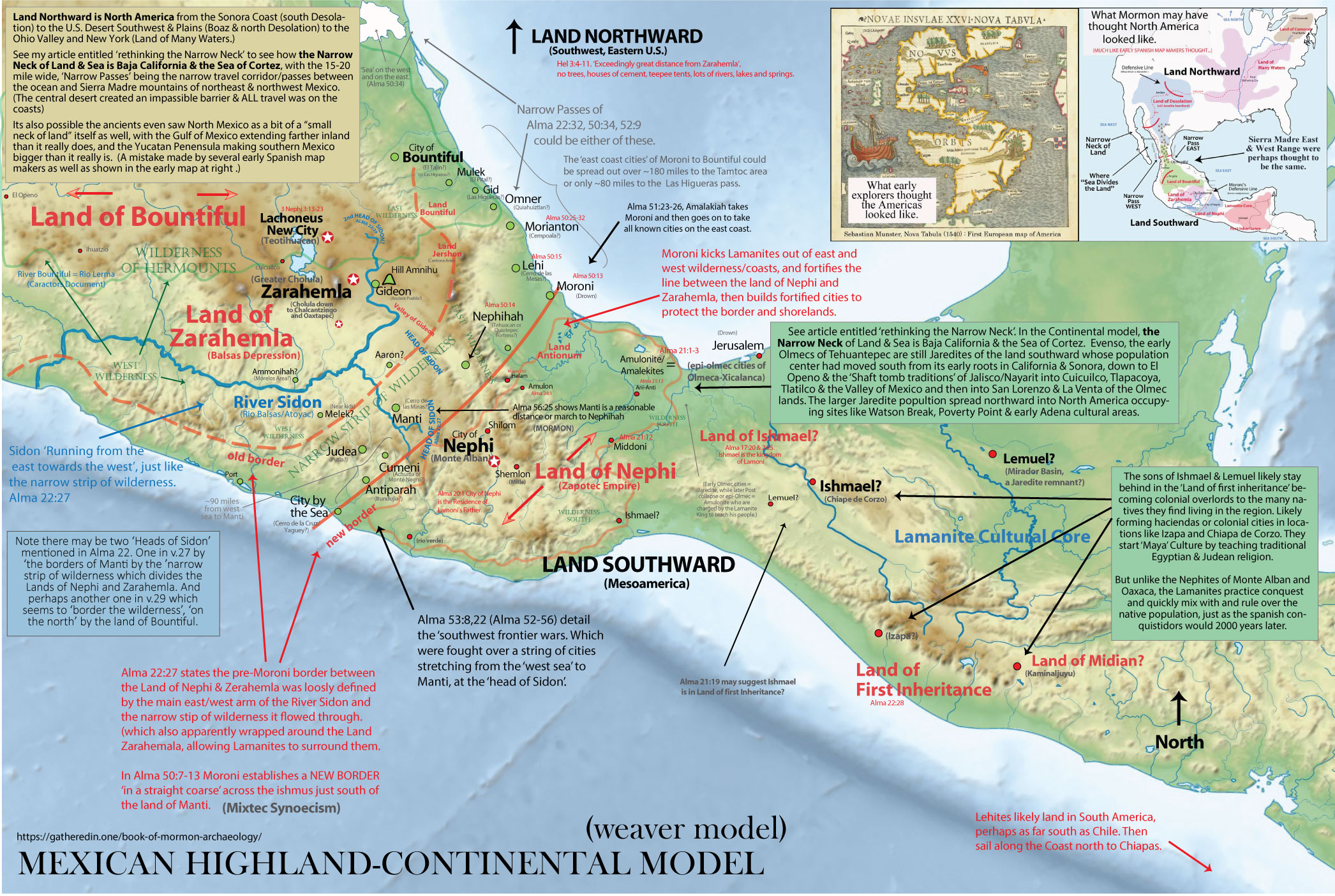
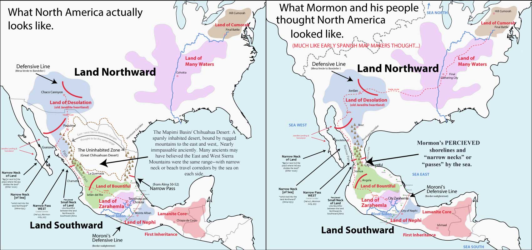
Illustration depicting the actual geography of North America versus what the ancient authors of the Book of Mormon may have thought the geography looked like. {Change defense line to names of cultures/bom peoples with dates of existence.}
The Continental Model of Joseph Smith
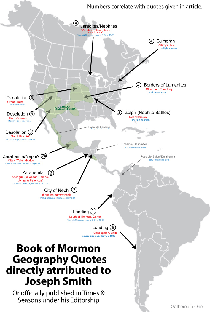
From the available documented evidence, it is apparent Joseph held a continental view of Book of Mormon Geography. Quotes by Joseph Smith or statements attributed to him point to a belief in four major areas of Book of Mormon happenings.
- He believed the Lehites to have landed in South America (refs)
- He believed them to have travelled to Central America to settle (with cities like Zarahemla being there). (refs)
- He believed them to have ‘lost their power’ (i.e. the Land Desolation) in the U.S. Southwest. (refs)
- He believed Cumorah and the final battle to be in New York, and much of North America to be the Book of Mormon ‘Land Northward’. (refs)
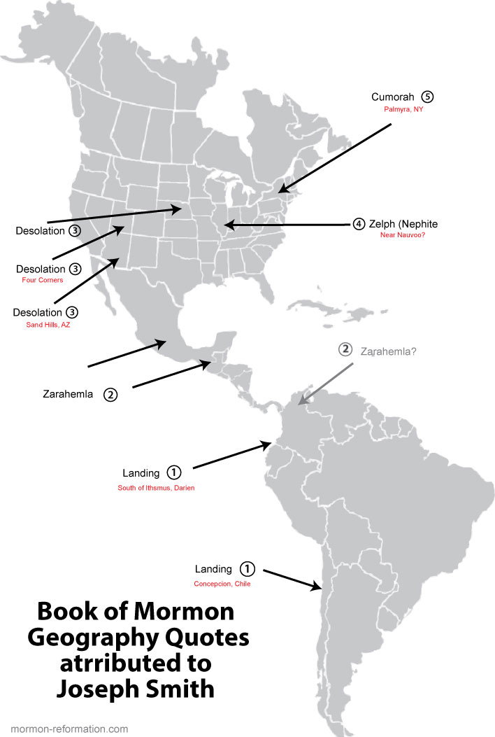
-quote of landing in Chile or a bit south of the isthmus of Darian
-quote of Land of Lehi (lands of Nephi, Zarahemla and Bountiful) was in Mesoamerica
-quote of Desolation being the Desert Southwest (ancient Puebloan cultures)
-quote of Cumorah and final battle being in New York.
Use my article AND the farms ones. http://mormonuniversalism.com/449/joseph-smith-quotes-on-book-of-mormon-geography/, https://www.fairmormon.org/answers/Book_of_Mormon/Geography/Statements/Nineteenth_century/Joseph_Smith%27s_lifetime_1829-1840, https://www.fairmormon.org/blog/2010/04/02/book-of-mormon-geography-in-joseph-smiths-day
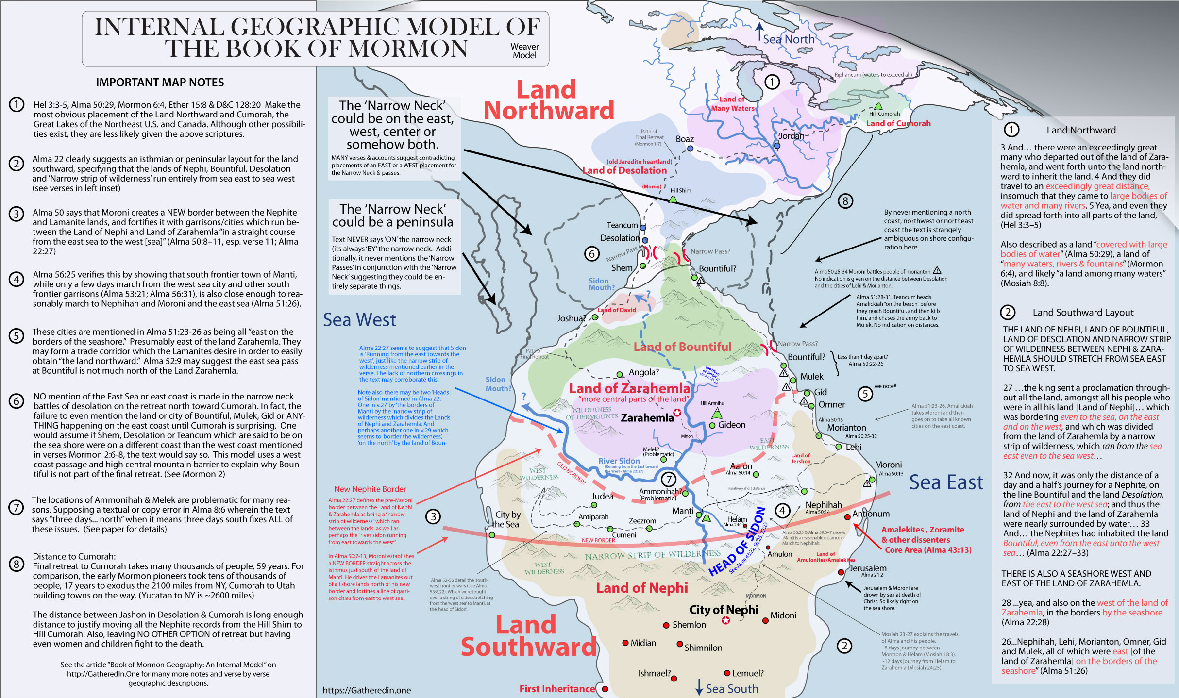
An Internal Model
Go through and do a one-page summary of needed internal model aspects. Get from intro to my already done internal model web article.
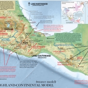
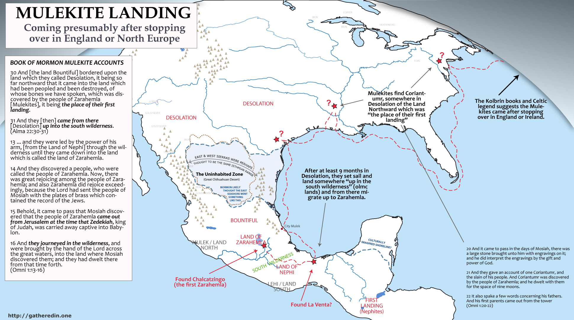
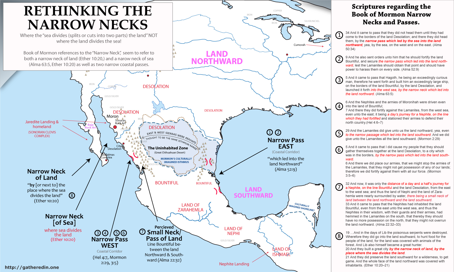
[pic of internal model]The Narrow Neck
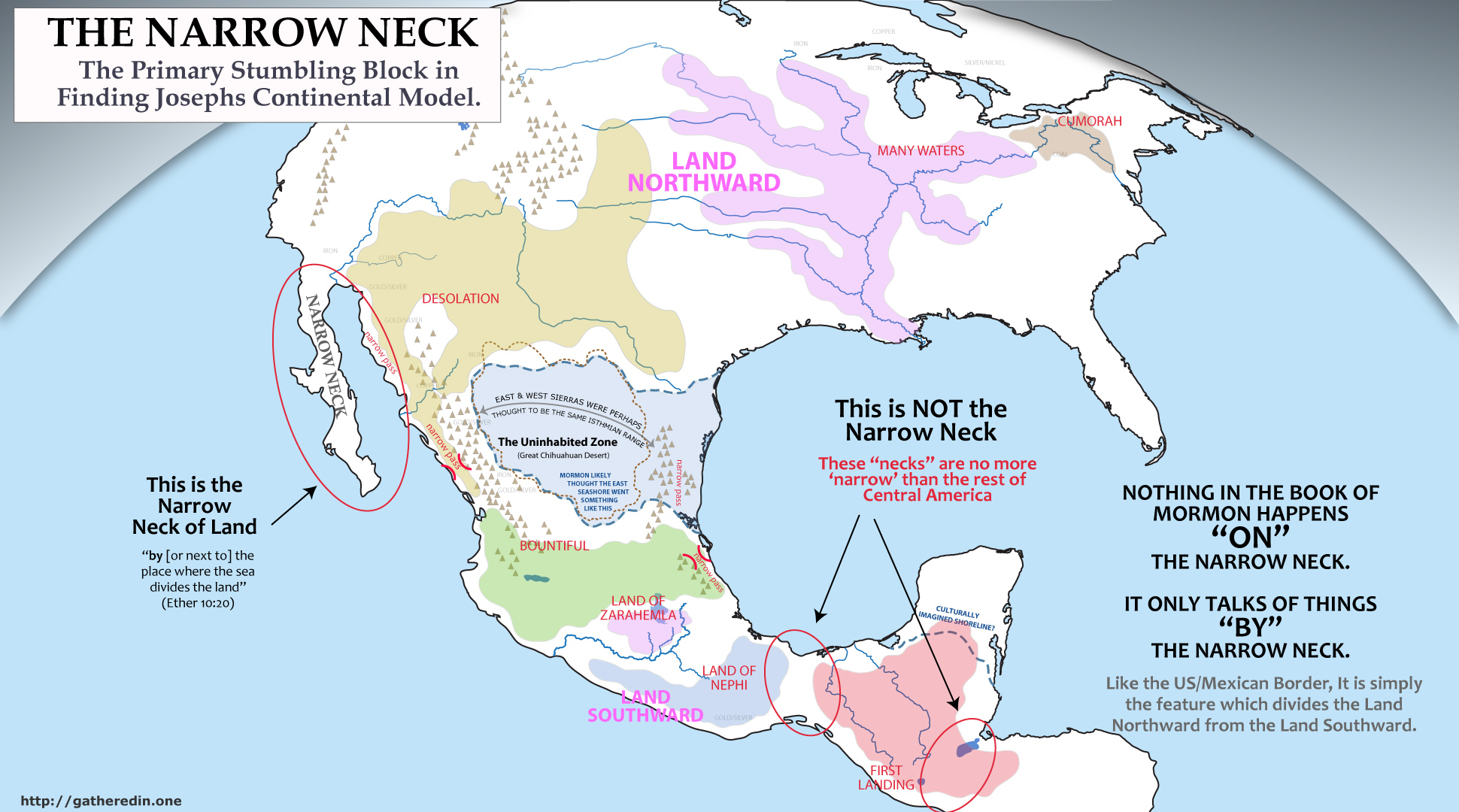
A study of ancient maps and geographies suggests that modern LDS Scholars have expected too much from ancient Book of Mormon authors by supposing pre-Columbian cultures had a modern understanding of continental geography and shorelines. Indeed, although many ancients understood well the spatial relationships for populated places, or places they had been, the understanding of uninhabited wildernesses and continental shorelines seems to have been very poor among cultures without widespread use of boats containing some type of nautical navigation technology.
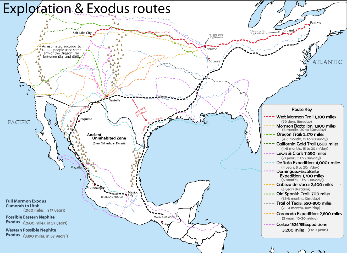
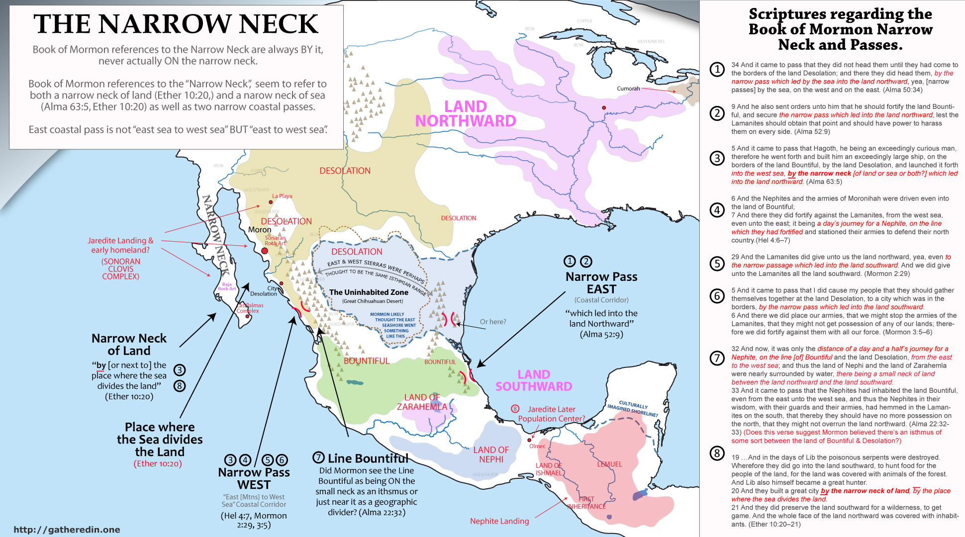
Our model proposes that much like Sabastian Munster’s early map of the New World, Book of Mormon authors seemed to have thought there to be another ‘narrow neck’ between the narrow coastal ‘passes’ of Northern Mexico. A misunderstanding likely caused by a belief that the Eastern and Western Sierra Madre mountain ranges were one and the same range. An easy mistake to make given their lack of travel through the nearly impenetrable and uninhabited Mapimi Basin of the Chihuahua Desert. Indeed historical texts show that essentially ALL travel & trade instead, occurred along the ‘narrow passes’ between the coasts and the steep mountain ranges, with only a few sparsely inhabited mining communities existing in the Deserts of the northern interior.
Note that Cabeza De Vaca, after being marooned in the New World and living with the Natives for years in regions all the way from Florida to West Mexico, still though late in life that northern California somehow shared the continent with Asia. He describes the mental geography he had created in his mind after living with the natives thusly.
[Pictures of the coastal passes from my 3d map with exaggeration.]These people [Southwest Natives] … must come from that part of Greater India, the coast of which lies to the west of this country, for they could have come down from that country, crossing the mountain chains and following down the river… As they multiplied, they have kept on making settlements until they lost the river when it buried itself underground, its course being in the direction of Florida. It [the Rio Grande] comes down from the northeast, where they [Coronado’s army] could certainly have found signs of villages. He [Coronado] preferred, however, to follow the reports of the Turk, but it would have been better to cross the mountains where this river rises. I believe they would have found traces of riches and would have reached the lands from which these people started, which from its location is on the edge of Greater India, although the region is neither known nor understood, because from the trend of the coast it appears that the land between Norway and China is very far up [in the North/Arctic]. The country from sea to sea is very wide, judging from the location of both coasts, as well as from what Captain Villalobos discovered when he went in search of China by the sea to the west, and from what has been discovered on the North Sea concerning the trend of the coast of Florida toward the Bacallaos, up toward Norway.
(The Narrative of Alvara Nunuz Cabeza de Vaca. Ch 6. v. 3)
REWRITE THIS ENTIRELY… The problem, of course, is that these overwhelmingly obvious correlations do not work with Mormon’s ‘narrow neck’, which is said to be north of Zarahemla and Bountiful. (As well as a few radiocarbon dating issues we cover in another section). Because of this, most serious LDS scholars have looked south of the isthmus of Teohuantepec, isthmus of Guatemala, or isthmus of Panama. A correlation which forces one to ignore EVERY major culture in North America apart from the Maya (the Lamanite core in our model). But of course, because essentially ALL the greatest Mayan cities are east of the possible candidates for the River Sidon, as well as significant issues with Moroni’s ‘east sea cities’ (ref), these models must throw out even the largest and most influential Mayan cities from any possible correlation with the Book of Mormon. With our continental model, essentially EVERY significant ancient culture in the North American continent, as well as their largest cities, are part of the Book of Mormon narrative. From the Maya to the Zapotec, Huestec to Mixtec, Teotihuacan and the Mexican Highland to the Toltec and Chichimec to the Ancient Puebloan/Anasazi to the Hopewell. The list goes on and on, of overwhelming correlations between the Book of Mormon text and archaeological ruins, geographic relationships, language relationships, Native American mythologies, settlement patters and more.
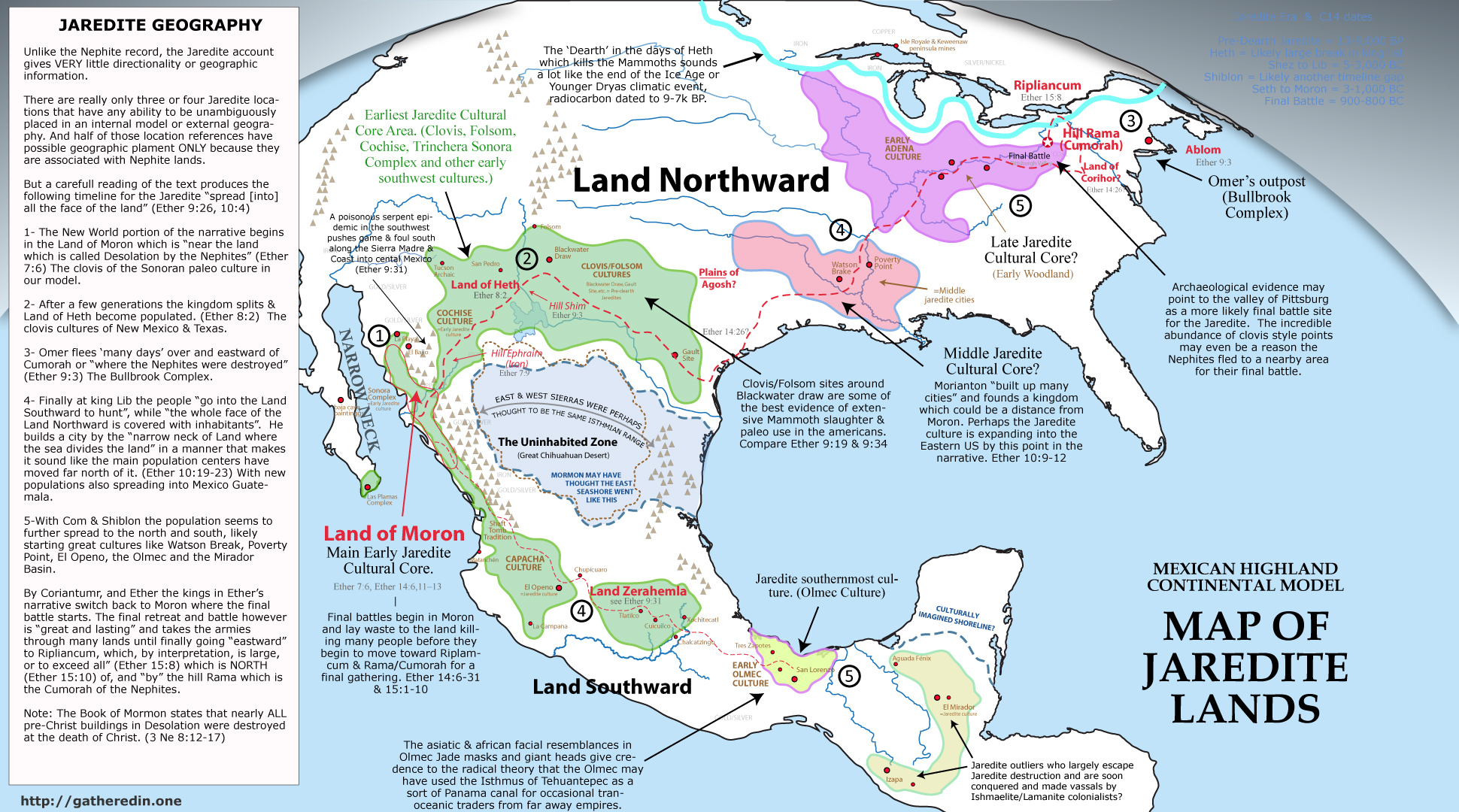
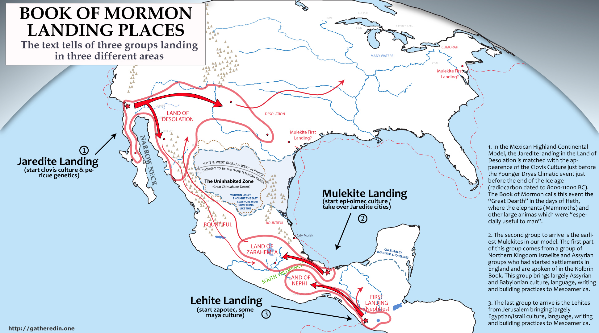
Arrival of the Jaredites
Start by talking about how it’s a channeling of a channeling.
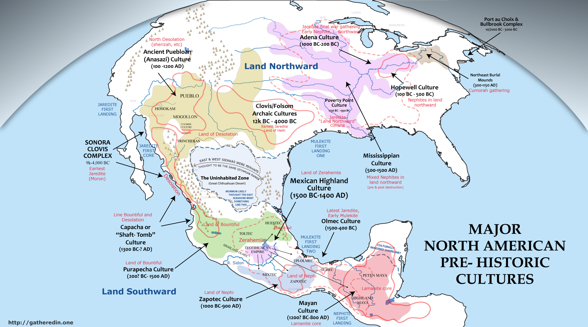
The Book of Mormon narrative explains that the Jaredite civilization was the first culture to inhabit North America and the only to coexist with elephants and other megafauna early in their history. (Ether 9:19, Note that for the early Jaredites, these megafauna were ‘especially useful for the food of man’.) It further states that a great dearth or climatological shift caused massive fauna migrations which the people followed, hunting them to extinction. (Ether 9:30,34)
Shouldn’t it be obvious that the only plausible archaeological correlation for the pre-dearth Jaredites is with the North American Paleo-Indians? (C14 dated from between 14,000BC to 7000BC) These were the first inhabitants of North America, and are the only North American cultures to interact with elephants (Mammoth and Mastodon). There are also many other correlations between these cultures but none have seen the similarities because of the difference between carbon dates obtained for these cultures and the dates inferred from the scriptural record.
The cultural center for two of the most notable Paleo-Indian peoples (the Clovis & Folsom) are located in the North American Southwest, which as both the Book of Mormon and our model show, matches with the Nephite land of Desolation.
Although modern scientific consensus is that these groups migrated from Asia to North America across the bearing straights, we believe that the Book of Mormon account of ship travel is equally plausible (given the 40,000 BC in-habitation of Australia). Diverse groups of ‘Jaredites’ spread out to cover North & South America, and we propose also migrating back into Siberia, Asia and parts of Europe.
We also suggest that the Jaredite account, like the Book of Mormon itself, was ‘channeled’ by the ancient author Alma from some ancient record which acted as a talisman or prop. In doing so, the ancient author projected his own biases and beliefs on the Jaredite record in the same way Joseph would have later done with the ‘translation’ (channeling) of the Book of Mormon.
Map of known ancient migrations, overlaid with possible path of Jaredite migration.
Omer and the Bull Brook Complex
As the early Book of Mormon ‘pre-dearth’ period in American prehistory was coming to a close, a small group of families left the core area and settled ‘by the seashore’ directly east of the hill Cumorah (Ether 9:1–13). The group of sites, in and around northeastern Massachusetts, are called the Bull Brook Complex by archaeologists. Clovis points found at several of the sites tie it to the Southwest.
Building on excavations by D.S. Byers in the mid-50s, archaeological societies in the Northeast have pieced together the history of the Bull Brook Complex. Their findings and subsequent analysis have shown the interactions of a system of organized, interdependent groups with specialized work force networks. It is recognized as containing the highest level of social structure in America at that time, which would be expected in a ‘refugee camp’ of the royal household.
As Moroni attests, the next archaeological period saw the rise of a richer and more diversified culture / . The Plano and Early Eastern Archaic Cultures fanned across the continent (S/H: around 1600-1200 BC; A/C: around 8500-6000 BC). Scientists have found the full spectrum of plants and animals corresponding to the days of Emer. See animals in the book of Mormon
Post-Dearth Jaredite Culture (Lib’s Empire & ____)
Moroni’s next exposition on culture comes in the days of Lib (Ether 10:18–28), who is based in the Land Northward [Adena culture of the Ohio Valley] but builds a southern outpost at a ‘Narrow Neck’ [Olmec culture of Mexico]. My corresponding period is labeled by archaeologists as the Middle and Late Archaic. Often indistinguishable from one another, these two cultural periods represent a major advancement over the preceding culture. Again the culture spread across North America from coast to coast. There were villages, agriculture, and widespread trade networks. South of the narrow neck, in the Mexican highland and beyond, the only inhabitants we find are organized hunting parties, which ‘coincidentally’ brought spear points of North American manufacture and style.
Scientists recognize metallurgy from this time period, and copper is the most common metal found. Many fine textiles have also survived from this period. Moroni says they made ‘all manner of tools to till the earth, both to plow and to sow, to reap and to hoe, and also to thrash’. He also says they had, ‘all manner of tools with which they did work their beasts’ (Ether 10:26–27). Most of the tools on this list have been found by archaeologists at sites dating to the Middle and Late Archaic. New weapons were also invented and manufactured, although archaeologists currently view them only as hunting weapons. Another major industry of the Jaredites was wood exploitation. A huge assortment of woodworking tools has been found at archaic period sites across the Nation.
This ‘southern outpost’ built in Mexico, which grew into the Olmec culture, to facilitate trade between the Atlantic and Pacific oceans even captured some trade from Asia. The ‘Jade Masks’ of the Olmec have obvious similarities and cultured ties to Chinese art and Jade work. We believe these ‘Jade Masks’ came from Chinese trade ships and will one day be conclusively tied to Chinese jade mines, and the ‘jade emperor’, through isotope studies. Archaeologists will slowly come to realize that ancient seafaring and trade was more widespread than currently thought.
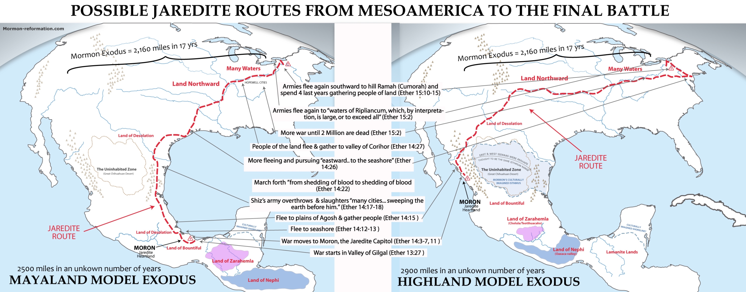
Olmec & the Fall of the Jaredites
Many Book of Mormon model’s attempt to match the Olmec with the Jaredites. In my model the correlation is more complex with the Olmec matching only the southernmost branch of the late Jaredite civilization; San Lorenzo corresponding to the ‘great city’ which Ether 10:19–28 says Lib built by the narrow neck. The culture that rose from Lib’s city is separate from the Jaredite heartland in the Land of Desolation [Southwest U.S.] as well as Lib’s capital which was likely in the Adena heartland of the Ohio valley (thus the similarities between Adena & Olmec mound structures). The ‘narrow neck’ mentioned in Ether is different from the defensive ‘narrow pass’ between Bountiful and Desolation mentioned by Mormon elsewhere in the Book of Mormon. There is no need for any ‘two Cumorah’ theory and most of the traditional issues with an Olmec/Jaredite correlation are removed.
From as early as the time of Nephi and Jacob, the Nephites of San Jose Mogote [city of Nephi] heavily influence the Olmec. As the Jaredite civilization collapses around 300 BC with the exodus of the elite to join the great Adena war, the new Zapotec/Olmec mix is called Epi-Olmec and is largely defined by the spread of the new Nephite (Zapotec) writing system. Before the Olmec collapse, their influence is seen readily in the early colonies of Izape and Chiapa de Corzo (Lamanite core), San Jose Migote (city of Nephi) and Mexican Highland (Mulekite core). In fact the early mixture of Nephite outliers and Lamanites with the epi-Olmecs sets the stage for the Book of Mormon’s Zoramites, Amalekites, Amulonites and other Nephite dissenters who effectually take control of remnant Olmec cities like Tres Zapotes after the Olmec collapse.
The Amulonite priests (Zapotec/epi-Olmec group of Oaxaca) were likely responsible for appointing teachers who began to train the Maya [Lamanites] in the same language and learning of Zapotec [Lemhites] and Mexican highland people [the Nephites]. With this new education the Maya began to prosper and make many technological advances. The sparsely-populated Mayan lands were soon covered with huge temples and city-centers with art and architecture reminiscent of the Zapotec and epi-Olmec style.
Colonial Arrivals & The Rise of the ‘Epi-Olmec’
In our article on the scattering of Israel, we detail how the Babylonian empire initiated a global colonial movement, matching closely with the European Colonial era 2000 years later.
In our model, colonies started in South America, the Zapotec of San Jose Migote [Nephites], and the Otomangue-speaking people of the Mexican highland [the Mulekites], who brought new and unique pottery & practices to the Americas; in each culture the pottery was already well-developed even at the earliest sites. (These new cultures can often be associated with skewed or erratic carbon dates going as early as 1500-4000 BC) The architecture and burial customs of these groups can easily be tied to the Old World. (Although nothing convincing enough has yet to be found to overturn the predominate belief of American/Eurasian no contact.) Square waddle and daub homes with storage pits in the floor dotted their lands. Their temples and public buildings are extremely similar to those of Egypt and Israel. Subfloor burials and burial positions also match those of the Middle East.
The Land of Nephi
San Jose Migote and the appearance of the 2 room temple and ‘men’s houses’. Also new religion. Find the article on this. The development of a valley separation.
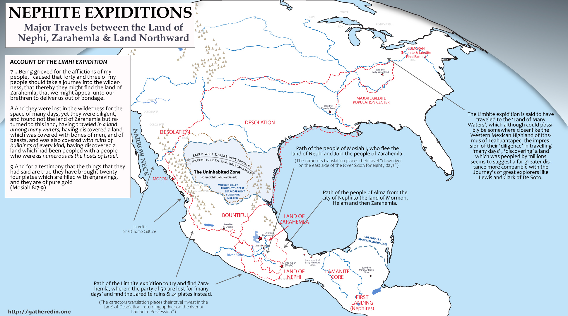
The Move to Zarahemla
At the dawn of the formative period there were several major demographic shifts which set the stage for the developing cultures. First, King Mosiah I and his people left the Land of Nephi [San Jose Migote/Monte Alban] and traveled to early Zarahemla [central Mexico, Likely Cholula at that time] to join the Mulekites (S/H: around 200 BC; A/C: around 1400 BC). This is seen archaeologically as an influx of Mixe-zoquean culture brings new advances to central Mexico, and public buildings begin to appear in the larger villages.
Archeological evidence in the Valley of Mexico also shows the appearance of epi-Olmec influence in sites such as Tlatilco and Tlapacoya. In our research, the early Nephite Zapotecs of Oaxaca effectively merge with the late Olmec [left over Jaredites from Great City of Ether 10:20] and are thus outlier Nephite peoples from before the move to Zarahemla, the late epi-Olmec may also be associated with the Amulonites who enslave the people of Limhi & Alma and build a short lived empire by teaching and exploiting the Lamanites (early Maya).
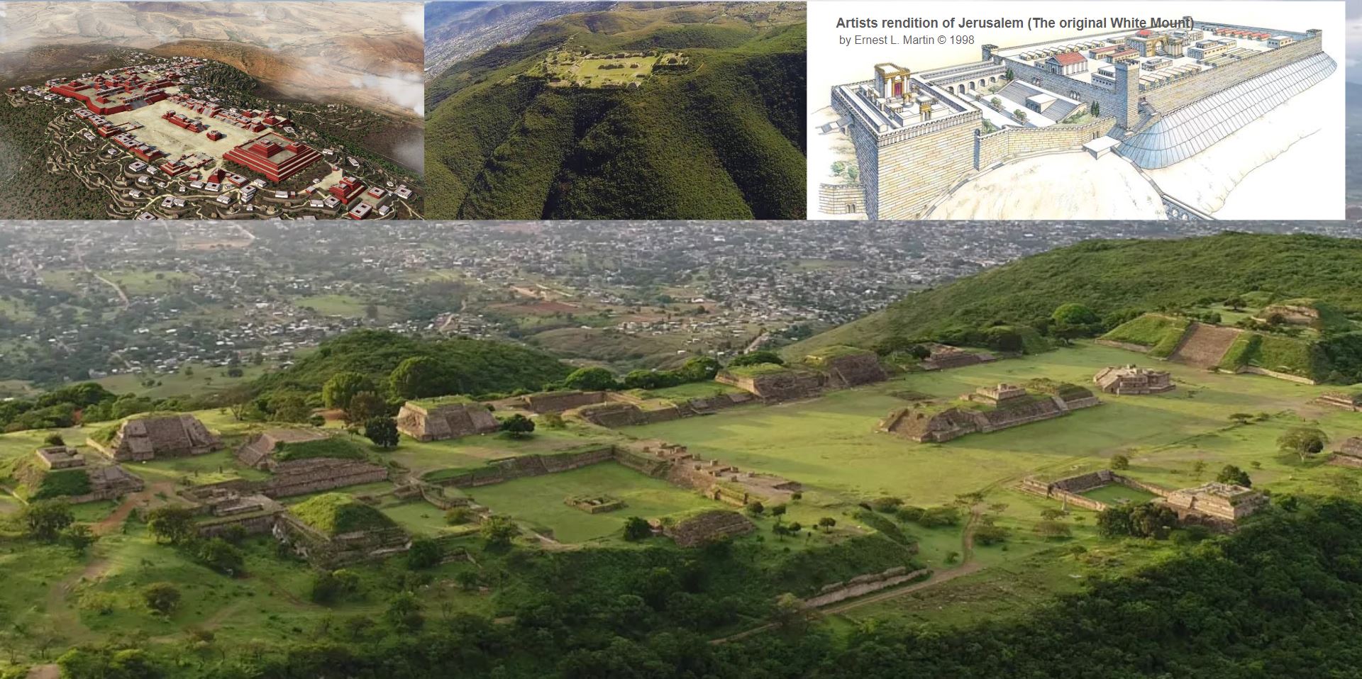
Zeniff Rebuilds Monte Alban, the City of Nephi
Back in San Jose Mogote [the city of Nephi], the city falls from its preeminence as the ruling elite leave [Moroni I] and those remaining are almost indistinguishable from their epi-Olmec trading partners. Shortly, however, high culture returned to the valley as Zeniff and his people arrive and begin to build anew a fortified city with public buildings and towers overlooking its neighbors [Monte Alban].
The new inhabitants of Monte Alban [people of Zeniff] were an elitist group which maintains strong ties to the Mexican Highland [Zarahemla] for hundreds of years afterward. Initially their culture was very similar to that of central Mexico (from which they had come), but the similarities decreased as time went on and they (the people of Zeniff, now led by King Noah) became extravagant in their prosperity. Lavishness dominates the architecture and material culture of this period. With the influence of Alma the younger, and his companions, and their conversion of Lamoni and his Father (and the expulsion of their loyalists who were likely centered in Mitla), the land eventually becomes a strong trading partner and vassal to Teotihuacan [Zarahemla].
Robert Zeitlin in his book “Questions about Zapotec Imperialism in Formative Period Mesoamerica highlights the research and archaeological evidence that Monte Alban was the center of an early conquest oriented empire. He says, “Recent Archaeological and epigraphic research suggests the existence of what could be Mesoamerica’s first conquest state centered at Monte Alban” (read this talk about how Nephi started the Empire, but when fighting with Mitla got to great they fled. However Monte Alban
Questions about Zapotec Imperialism in Formative Period Mesoamerica: https://www.jstor.org/stable/281646
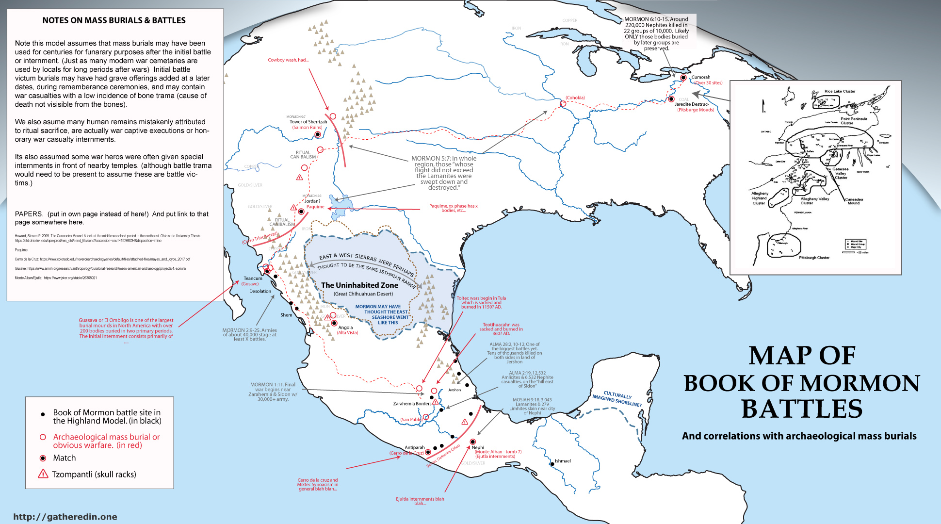
The emergence of the Zapotec Military State
Give a bunch of quotes and data here.
The evidence for the emergence of the Zapotec military state in the later formative is an AMAZING match to what we expect from the Book of Mormon text after Lemhi abandons
Make a time line chart of events of city of Nephi from first to second abandonment and reoccupation by Lamanites.
See Military Expansion outside the Valley of Oaxaca: (C14 dates on burning of monte alban & surrounding fortresses) https://europepmc.org/article/PMC/208841
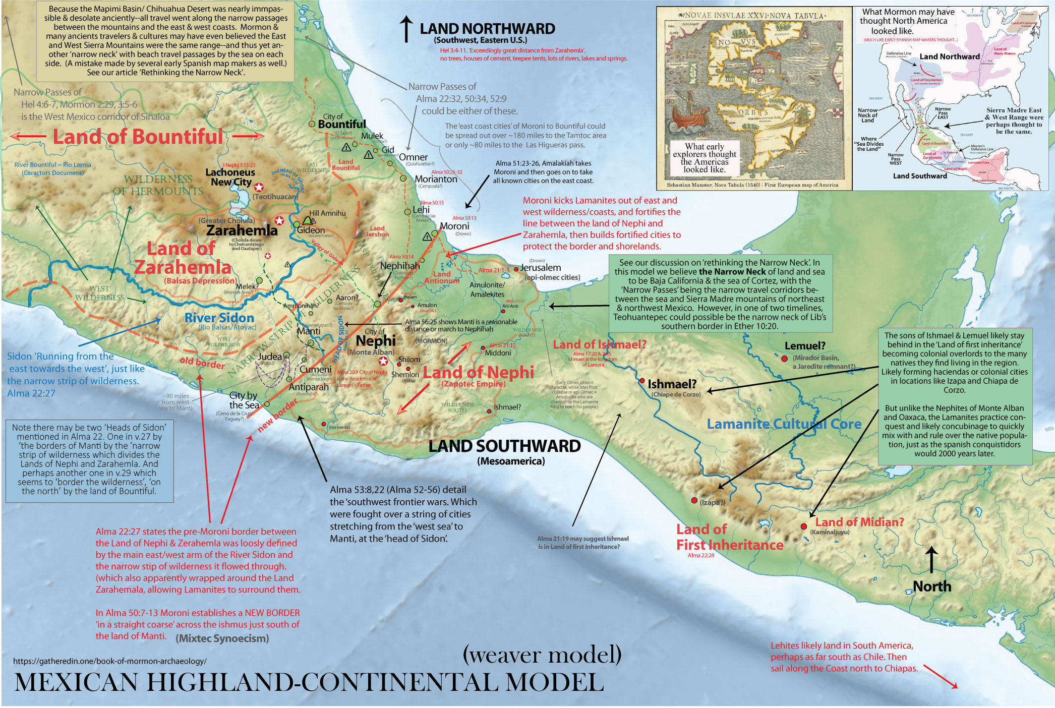
Alma 22’s General Geography of Book of Mormon Lands
In Alma 22, we are given perhaps the most comprehensive general overview of Book of Mormon geography…. (he wants us to find it? Go over piece by pieace.
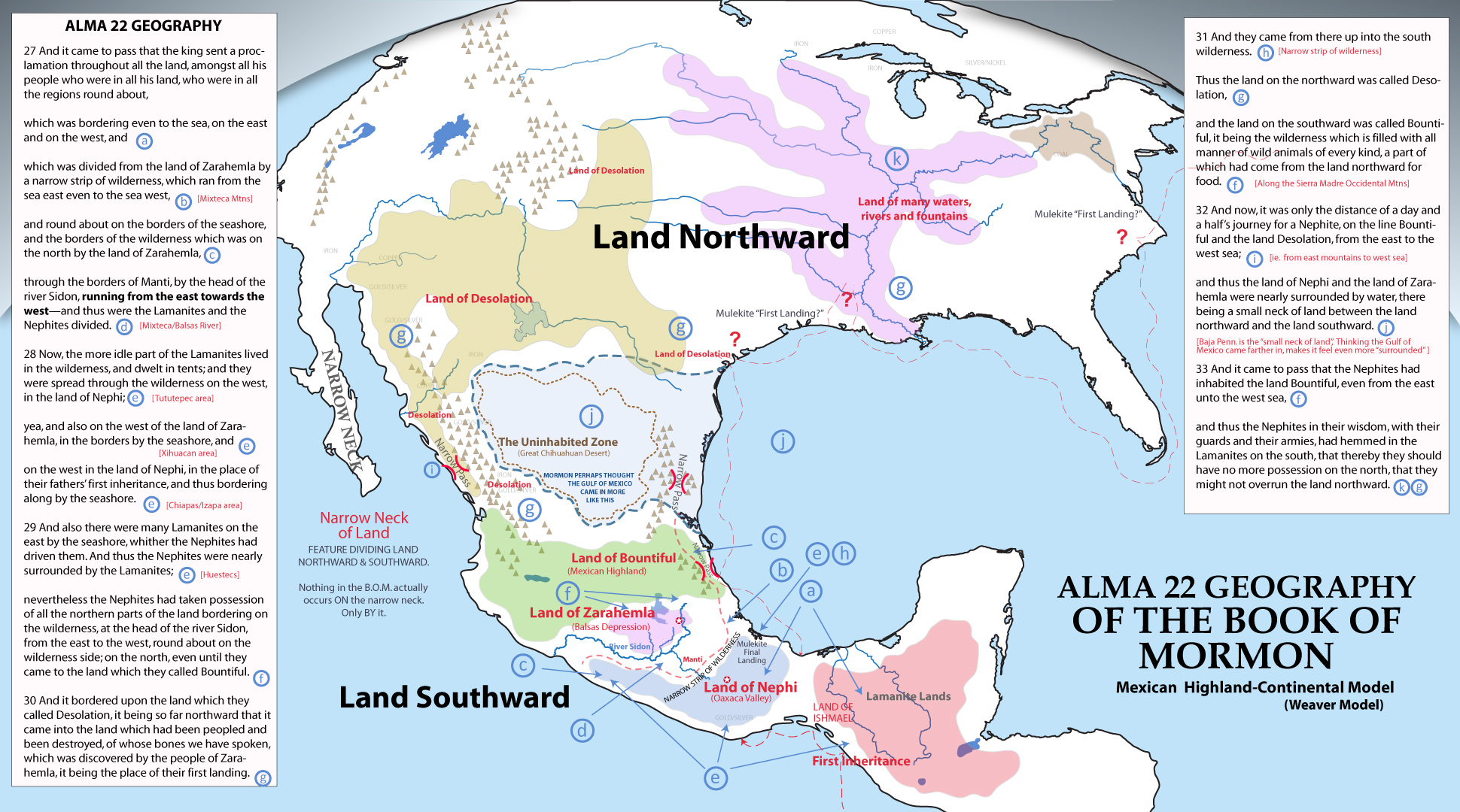
Captain Moroni: Fortifying the Mexican Highland & Mixtec Synoecism
Outline: Although scattered walled or fortified cities occur throughout the mayanlands, perhaps no where in Mesoamerica was it as ubiquitous as the Mixtec & Huestec lands. The string of fortified cities matches perfectly with the ‘backwards L’ laid out in Book of Mormon’s internal geography. But perhaps more impressive is the way that archaeological digs shows these fortifications came about. Authors like x,y & z suggest that warfare likely caused hundreds of hamlets in the Mixtec regions to consolidate into walled hilltop fortresses during the later formative precisely when the book of Mormon says… (get archawolocical quotes and bom quotes)
Mixtec Highland cities in our Manti region like Monte Negro, Huamelupan, Cerro Jazmin, Yucuita, all consolidate around the same time in the late formative. Also cities of the lower Verde Valley like Rio Viejo, Cerro de la Cruz, Yugue and Cerro de la Virgen and San Francisco de Arriba. (add map of all these cities. In the west Cerro de las Mesas was built during this time and is almost certainly associated with the city of Moroni (which was inundated at the death of Christ). La Coyotera & Quiotepec Fortress in the Teuacahn Valley are almost certainly Nephihah and date to right around the time of Moroni. These cities changed hands multiple times and were likely held by the Zapotec/Lamanite regime of Monte Alban more often than the Nephites of Cholula.
These two great nations, the Nephites on the Mexican Plateau and the Lamanites [Maya] in Southern Mexico, Guatemala and Yucatan, began to experience greater conflicts. Foreseeing the coming challenges, Captain Moroni prepared his people and their lands. First, the weak lands were fortified and the southern frontier was strengthened. Hilltop fortifications began to dot southern Mexico in Veracruz, Oaxaca, and Guerrero. Great urban fortresses were created. No wonder Mormon venerated the leadership, courage and vision of Captain Moroni and the manner in which he prepared his people for war.
After Amalickiah’s first attack, a second phase of construction was begun in which fortified cities and hilltop fortresses were built throughout the land of Zarahemla which appears to have stretched from Oaxaca to Jalisco and from southwestern Michoacán to northern Veracruz. Also, the Book of Mormon records Moroni pushing the Lamanites out of the east wilderness and on the west, then building new cities in these areas in order to create a more defensible border. Excavations in southern and western Oaxaca and Guerrero, as well as central Veracruz are now showing such movements of peoples and the construction of new large defensive cities and fortresses.
During the time that fortifications were being built in the Mexican highland, a massive weapons production industry commenced throughout Mesoamerica, both in the Mexican Highland [Zarahemla] and in Maya [Lamanite] lands. To accommodate these war preparations, the peoples of the Mexican Highland [Nephites] made major breakthroughs in agriculture and built massive irrigation systems. From that time forward, urbanization and trade specialization, with accompanying prosperity, enveloped the Nephite lands.
The great war of Moroni’s time, and the wars that followed, are seen archaeologically in demographic and cultural movements of this time period, and in numerous monuments depicting warriors and captives in both Highland Mexico and Maya lands. The Lamanites displaced and jumbled the Nephites numerous times. There was also a great cultural mixing when groups of Lamanites converted to the Nephite religion and went to live among the Nephites, and also when groups became captives. Cities experienced occasional upheavals, but most of them changed hands without noticeable ruin.
War on the east & southern fronts
Add section. Map movements
References.
The People of Ammon in Jershon
Book of Mormon says the people of Ammon were mostly women. After the death of most the men among Ammon’s converts the remaining people buried their swords and fled for refuge among the Nephites. After travelling to Zarahemla they were given the land of Jershon, the location of which was said to be,
…on the east by the sea, which joins the land Bountiful, which is on the south of the land Bountiful; and this land Jershon is the land which we will give unto our brethren for an inheritance. (Alma 27:22)
Later when the armies of Zoramites prepare to battle the people of Ammon (because they had given refuge to the Zoramites who were expelled), the people of Ammon flee “over into the land of Melek” (Alma 35:13).
Our model places the eastern coast cities of Bountiful, Melek, Moroni, Aaron, Nephihah and Jershon on the east Coast of Mexico stretching somewhere between Tampico on the north and Veracruz (or more likely El Tajin) on the south. Many fortified settlements, castles and towers are found within the small stretch of coastline. Among them lies a coincidental correlation between the city of Tamtoc (aka Tamtok) and the people of Ammon.
Although Tamtoc reached its zenith in the late classic, archaeological evidence has determined the city was founded as early as 600 BC by Olmec (Jaredite) peoples. If a correlation to the people of Ammon is to be made, better dating of the mostly female remains would need to be found to fit into a window of closer to 100BC to 200AD. The latter date assuming that the early Book of Mormon women of this community started a legacy of feminine predominance which lasted at least a few centuries after its establishment.
Approximate routes and dates of the proto-Huastec and other Maya-speaking groups
One of the characteristics that distinguish Tamtoc is the remarkable female presence. To date, 90% of the burials discovered there are of women. Furthermore, they are represented in most of the clay and ceramic figurines found here and that are thought to have a high rank in the social division of the community. The sites iconography touts a sculpture of a “priestess” (dated to as early as 600 BC) and “the Scarified Woman or Venus of Tamtoc”, which has been interpreted as glorifying…
Perhaps one of the most striking correlations between this city and the Book of Mormon narrative is the linguistic evidence which suggests that the language of the “Huestec” culture which permeated Tamtoc came from the Putin Maya region of Oaxaca and Southern Mexico (our land of First Inheritance). ref.
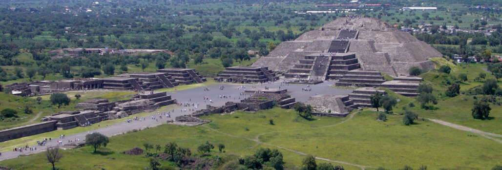
Lachoneous and the Founding of Teotihuacan
Just before the time of Christ, the combined guerrilla forces of ‘The Gadianton Robbers’ became so numerous as to warrant an unprecedented sociological experiment. All the people of Nephi temporarily abandoned their cities and moved to a new area in ‘The Land of Zarahemla’ (3 Ne 3:13–23). In our model, the urban city built for these immigrants was the great city of Teotihuacan. The old city of Zarahemla (likely Cholula or Cuicuilco) was too exposed and near the forests where Guerrilla fighters could hide, as well as being threatened by volcanic eruptions. So with hundreds of thousands of refugees and immigrants, what was likely the largest pre-planned city in the world was born. In the middle of a large open defensible valley, Teotihuacan was built with the refugee cultures in mind, with defined quarters for each major culture. The Zapotec from the land of Nephi, the Mixtecs from Gideon, and the Totonac and epi-Olmec from the lands of Melek and Jershon, and even Nahua peoples from the land of Desolation and fleeing Lamanites from the Mayan lands.
The city contains some of the largest structures on earth, with the pyramid of the Sun and Moon rivaling the Great pyramids of Egypt. At its zenith a hundred or so years after the time of Christ there were likely up to 250,000 inhabitants in the 11+ square miles urban area, not counting the many, many satellite communities.
The city would soon come to be the de-facto political and religious capital of Mesoamerica, holding rule and influence of peoples from the Lamanites of Guatemala to Anasazi of Arizona and New Mexico (land of Desolation).
Cataclysms at the Coming of Christ
The Book of Mormon suggests a global reaching cataclysm at the death of Christ, causing large scale destructions to North America and “the isles of the sea” (3 Nephi 8-9, 1 Ne. 19:10–13, Hel 14:20–24, 1 Ne. 19:10) which are contrasted with more the minor phenomena of an earthquake and three hours of darkness in Israel and Eurasia at the same time in the Bible (Matt 27:51–53, Mark 15:33, see also Phlegon, Thallus, Africanus and Tertullian).
Many authors have shown how some of the destructions described in 3 Nephi 8-10 in the Book of Mormon could be attributed to a large volcanic eruption. However, the shear extent of cataclysms in MULITIPLE lands seemingly involved not only volcanic phenomena such as earthquakes, lightning, darkness, tempests and fire from heaven. But also regional tectonic and coastal changes where ‘cites… had been sunk, and waters came up in the stead thereof [which]… could not be renewed” (4 Ne 1:9). As also unprecedented tectonic changes to some degree which caused the “whole face of the land [to be] changed” (3 Ne 8:12), wherein the “highways were broken up” (v.13) and “many notable cities” were sunk, burned, shaken to the ground and left desolate (v14), with mountains and valleys left in their place (Hel 8:23). In one instance the texts states that the “earth was carried up upon the city… that in [its] place there became a great mountain” (3 Ne 11:10). This language is quite different from what one might expect from landslides or volcanic ash flows where earth would be carried down upon a city.
Such overwhelming natural disaster reminds one of the mythical tales of destruction common in historical literature and are nearly ubiquitous in Mesoamerican codices involving their gods and cultural heroes (ref). Reasonably, one must accept the possibility that Book of Mormon authors used hyperbole and mythical embellishment in their records to explain the destructions which preceded the coming of Christ to America.
If, however, we would seek to take the Book of Mormon text at face value and propose a literal, unembellished nature to these destructions, we must become inventive in our theories and turn to what we know of astronomical physics to suggest a few possibilities. Many authors have suggested a simple volcanic eruption, which of course falls short of the kind of widespread global darkness, volcanic, atmospheric and tectonic destruction described in the text. Instead, we must find a mechanism which could cause global darkness and seismic activity and widespread volcanism, yet affecting one hemisphere far greater than the other—and likely a correlation or relationship to a ‘new star’ appearing some 30 years earlier.
The most likely suspect would be some type of pulsar or large supernova at Christ’s birth, which in turn knocked local cosmic debris into the path of earth causing an asteroid impact to hit the Pacific Ocean some distance off the West Coast of Northern Mexico just after His death. This atmospheric and seismic waves from this impact (as well as a possible accompanying CME from solar impacts) then was responsible for the simultaneous atmospheric and tectonic cataclysms mentioned in the Book of Mormon, ancient Mesoamerican codices the Bible and early Christian historians (Phlegon, Thallus, Africanus and Tertullian).
The effects of such an event have been modeled to show that it could indeed account for many of the destructions described in the Book of Mormon. Galen Gisler and scientist at Los Alamos laboratories have created a visualization which shows.
-supernova, pulsar, asteroid, MOON hit, and tidal effect on both water & land/tectonic shift. Use this study/visualization by Galen Gisler at LANL & los Alamos … awesome! https://gizmodo.com/heres-what-would-happen-if-a-giant-asteroid-struck-the-1790084340 https://www.youtube.com/watch?v=95z0qRNFFxs use this in your videos and presentations! Make an image, to put in book (with notes explaining the tsunami, seismic waves, atmospheric compression waves, heat wave and water vapor. Also radiocarbon introduction & production in ocean & atmosphere.
Not hard to believe given Meteor Crater Arizona (dated to 50,000 BP) and Sirente crater Italy, dated to 412 AD, or the Tunguska event
2 Simulation of an asteroid impact over the ocean done by Galen Gisler and scientist at Los Alamos labs. Finding show that tsunami danger is not as large as before suspected, but significant danger exists from seismic waves (if contact is made with ocean floor), atmospheric compression waves, atmospheric heat wave and ejected water vapor. Weather disruption is inevitable. Our model also theorize substantial radiocarbon production and a lasting marine reservoir exchange downwind from the affected ocean water.
-be sure to hit the idea that the pre-Christ land of desolation would have been DESTROYED by the west coast tidal waves in the scenario. Also that it would affect radiocarbon dates…
[You need to make an illustration showing radiocarbon spike of BOTH the atmosphere and ocean area, and show on the graph lines correlation what 4 points on the line would do to correlated dates—on both the up and down (atmospheric up would be instantaneous, marine carbon exchange would be gradual up and down. And point out that nuc tests increased CO14 100%! Even a 20% increase would mean a date adjustment of ___ years. (calculate it). Put it next to the graph of what nuclear testing did. Note its different that marine reservoir effect, which has to do with eating marine animals, the marine exchange is when high atmospheric levels are absorbed into surface waters (and worked deeper), and then recursively contaminate atmospheric carbon levels for possibly hundreds of years even after the atmospheric levels have mixed back to normal (a process only taking 100 years or so, as seen with 20th century atmospheric nuclear testing)]WORK IN? In our model, we put forward two theories to explain the cataclysms at the death of Christ mentioned in the text. The first involves a massive astronomical event such as a supernova or pulsar (seen as a ‘new star’) began a chain reaction of plasma and debris which reached earth around 34 AD. This massive plasma stream and debris in turn caused meteorites, as well as a possible impact large enough to cause very slight changes in the earth’s angular momentum (see nutation or ‘chandler wobble’) which was responsible for driving a pulse of increased flex and subduction pressure on the Pacific, Cocos and Nazca Plates at the time of Christ. This minor tectonic pulse event initiated an unprecedented earthquake, widespread volcanism, orogenic movement and thrusting which were recorded in the Book of Mormon as regional destructions in both their land Northward and Southward.
Radiocarbon Dates & The Mayan Calendar
OULINE OF SECTION
-two possibilities of why things don’t line up. ONE is radiocarbon dates are wrong. TWO is that Mormon & moroni made a mistake in their timeline. There is good evidence of both.
-The dates of ‘record keepers’, in 4 Nephi/Mormon 1 would require each person to live to preposterously old ages; and moreso, to sire children at absurdly old ages. Note that about 110 years after Christ’s coming Nephi gives the record to his son “Amos” (4 Ne 1:19–21), who keeps it for 84 years before dying in 194 AD! Since we know Nephi was old enough to take charge of the Church at Christ’s coming we can suppose he was between 25-40 at Christ’s coming in 34 AD. This means that he would have had to been at least 100 years old when he gave the records to his young son Amos who then lives at least another 84 years himself before dying. So if Amos was 12-20 when he got the records, Nephi would have had to father him at the ripe old age of at least 80-88 years of age!
This gets worse in the next generation as Mormon writes in 4 Ne 1:47 that Amos dies in 308 AD and gives the record to his brother Ammaron. But this doesn’t work at all since 4 Ne. 1:20 told us Amos kept the record 84 years (after about 110 AD) which should put us around 194 AD when Amos gives up the record and dies. So we have at least 114 years unaccounted for. Because of this discrepancy, some have speculated that Amos had a son which the text does not mention, who was also named Amos, so Mormon is simply talking about 2 different Amos’s. However, even this theory would require Amos I having Amos II at over 100 years old! This leads us to draw a more natural conclusion that there was simply a “break” in the record which Mormon glosses over in order to make sense of the “400 year prophesy” and his belief that he lived around 400 years after Christ.
However, what if there were TWO Quetzalcoatl’s? Many archaeologists and Mesoamerican historians believe that a King took over the title Lord Quetzalcoatl nearly 700 years after Ixtloltalx tells us that the true Lord Quetzalcoatl came…. finish
Our model suggests two possible reasons for why the dates for the collapse of the continent doesn’t line up….
[MAKE AN ILLUSTRATION OF THE SIMILARITIES….]-Both have a start date known to be somewhere around 3-4,000 BC. (the Hebrew calendar ‘Ano Mundi’ is currently believed to be 7 October 3761 BCE, although some ancient scholar placed it as early as 4500? BC. The Mayan calendar also has an ano mundi start date. I originally had several theorized start dates, ranging from xxx to yyyy (ref). With radiocarbon dating (ref) it was placed at 3114 BCE, but by putting it closer to the accepted ‘Hebrew Calendar’s start date of 3761 BCE, the Stella dates seem to ‘coincidentally’ ALL fall into the window of Book of Mormon history (reword).
-They both use a type of ‘Jubilee’ year of remarkably similar duration. 49/50 years in the case of the Hebrew Calendar and 52 year ‘Haab’ in the case of the
-They both also have a lunar calendar of ‘weeks of the moon’, which realigns with the solar calendar every ~70 years (52 Haabʼ cycles of 365 days equals 73 Tzolkʼin cycles of 260 days: or 520 years) Is AMAZINGLY similar to the biblical calendar given in Daniel/etc where 10×49 Jubilees equals 70×7 Sabbaticals (490 years). NOTE Ixtlilxochitl says one epock is 520 years which is 5 ages (10×52 yr cycles)
-They both have an important cycle of 40 (for maya its 20 or a ‘score’). Using columns it ends up being 7 columns of 40 (for 260 completion) and 10 columns of 40 (for 360 day completion). See- https://youtu.be/1qLraLs8Y14?t=714
Just like in Egyptian archaeology, We might assume that archaeologist were once again misled to using an incorrect date to the beginning of the Mayan calendar. Their C14 dates leading them to utilize a date of 3114 BCE, when in fact the correct date is something far closer to the beginning of the Jewish calendar of 7 October 3761 BCE. This would put their long count dates off by approximately 647 (~650) years! Thus the earliest dates of 36 BCE at Chiapa de Corzo and Tres Zapotes would actually be a date of 683 BC (Putting us in the neighborhood for Mesopotamian colonization. Perhaps marking yet ANOTHER middle eastern group coming to the New World after the Assyrian regional wars.) This would also put some of the latest dates closer to 400 AD? (find some of the latest dates)
3 Changes in atmospheric and oceanic radiocarbon caused by nuclear testing. by Lawrence Livermore National Laboratory.
————————-
The Golden Age of Zion
Major population centers
As the ash settled, a new culture spread across the land. In some ways, this new culture was more monolithic; in other ways it was more diverse. Throughout the Americas a new two-room temple replaced varying former styles. A utopia of peace and prosperity is spoken of in legends. There is less evidence of weapons being used at this time, and the murals, figurines, and architecture show designs of nature, lines of symmetry and harmony, and displays of pleasant animals and domestic life. Gone are all signs of a military elite, governmental force, and coercion. The Hopewell, the Anasazi, the Mogollon, Teotihuacan, and the Maya; continent-wide the traits are the same. The great peace resulting ‘because of the love of God which did dwell in the hearts of the people’ (4 Nephi 1:15).
The people were united in righteousness, yet at the same time, the culture became more diverse, as the focus turned from making a profit to making quality products and upholding the ideals of family and community. Local artisans replaced the mass-production and expansive trade networks of the preceding period. Thus there was no need to travel extensively ‘on business,’ so people could spend more time with their families. Family gardens replaced mass-produced food. People ate a greater variety of food, but their food was of more local origin. Analysis of skeletons shows that the people were healthier and enjoyed longer life spans than during the preceding period. The arts flowered during this period. The number and variety of musical instruments greatly increased. Pottery and other goods became more useful and more beautiful, and less ornamental and extravagant. A much greater variety of artifacts is found, but in much smaller quantities than before, and with much less waste. The prosperity was great throughout all of the Americas and in all areas of human development, ‘because of their prosperity in Christ’ (4 Nephi 1:23).
In the early classic period the church became very wealthy. The people donated their time and skills to the creation and maintenance of beautiful temples and public centers. The population exploded, but at the same time, the cities became less dense as the communities were reorganized and the people spread out across the land. Even the biggest ‘cities’ were only lightly populated, yet they contained ceremonial centers and public buildings large enough to accommodate all the people of the surrounding villages. Social classes disappeared, yet the standard of living increased everywhere; And ‘they were in one, the children of Christ, and heirs to the kingdom of God’ (4 Nephi 1:17).
The Land of Desolation
There is no other region in North America which matches so perfectly the Book of Mormon’s description of the land of Desolation than the desert southwest and its ancient Puebloan cultures. From its desolate, treeless landscape to its ubiquitous use of cement, rock and adobe to build its ‘houses, cities, temples and synagogues’ (Helaman 3:9), there is simply not a single aspect of
- Extensive trade and cultural integration with Mesoamerica. With over 200 Mesoamerican ball courts in the region, as well as caged McCaw found in Paquime, countless shells from the West Mexican coast and overwhelming use of Mesoamerican Cocoa and Agave.
- Even into colonial times the predominate travel and trade corridor from the desert southwest into the Mesoamerican lands went through the ‘Narrow Pass’ or 15-20 mile wide narrow coastal zone of West Mexico between the narrow sea of Cortez and the sharply raising Sierra Madre Occidental mountains. (In fact, the identical names of the mountains, and the impassible nature of the Mapimi Basin between, gives evidence to the idea that the natives believed the east and west Sierra Madre Mountains were one and the same. Creating a mountainous ‘narrow neck of land’ between the Southwest and Mesoamerican cultures. With ‘narrow coastal passes’ of about 15-20 miles or a days journey on either side)
- The most extensive use of ‘cement’ (Helaman 3:9) or adobe on the continent. Also directly next to the region with the most extensive use of ‘tents’ (ref) or teepees on the continent.
- The Southwest Kivas are likely the most widespread evidence of local religious rooms or ‘synagogues or sanctuaries’ (Helaman 3:9) in North America.
- Widespread evidence of war, massacre and cannibalism. (see Moroni x;z)
- Mosiah Hancock even quotes Joseph Smith as saying the desert southwest was ‘where the Nephites lost their power’. (ref)
- When a tree would spring up, they would preserve it.
- The ‘Las Trincheras’ Line of defenses from Sonoran coast to Paquime. Exactly what we’d expect after the treaty made with the Lamanites (ref).
- Overwhelming evidence of warfare, massacre, regional burning, cannibalism and even towers and heaps of earth with dead bodies and remains (refs). Exactly what might be expected from a massive
Could there be any better match to what the Book of Mormon says about the land of Desolation than that of the Desert Southwest of the U.S. and Northwest Mexico?
5 Yea, and even they did spread forth into all parts of the land, into whatever parts it had not been rendered desolate and without timber… And now no part of the land was desolate, save it were for timber; because of the greatness of the destruction of the people who had before inhabited the land it was called desolate…
9 And the people who were in the land northward did dwell in tents, and in houses of cement, and they did suffer whatsoever tree should spring up upon the face of the land that it should grow up, that in time they might have timber to build their houses, yea, their cities, and their temples, and their synagogues, and their sanctuaries, and all manner of their buildings.
10 And it came to pass as timber was exceedingly scarce in the land northward, they did send forth much by the way of shipping.
11 And thus they did enable the people in the land northward that they might build many cities, both of wood and of cement.
Note what southwest archaeologist, Allen Denoyers, writes about the construction of Hohokam and other ancestral Puebloans of the Southwest. “They wouldn’t pull out the plants [trees]. which grew along side of the [sic] River which provided [sic] willows, for the necessary wall and roof support, for the Hohokam pit house, instead they would cut the plant and it would grow back the next year and more homes could then be built. And… the wood was carried a great distance, climbing into the Catalina Mountains and carrying it many miles home.” This practice was fairly ubiquitous in the desolate landscape of the Southwest, where pit houses and Great Houses alike competed for scarce trees which grew only along river channels and in near-by Mountains. (Reference: https://southwestphotojournal.com/tag/honey-bee-village/)
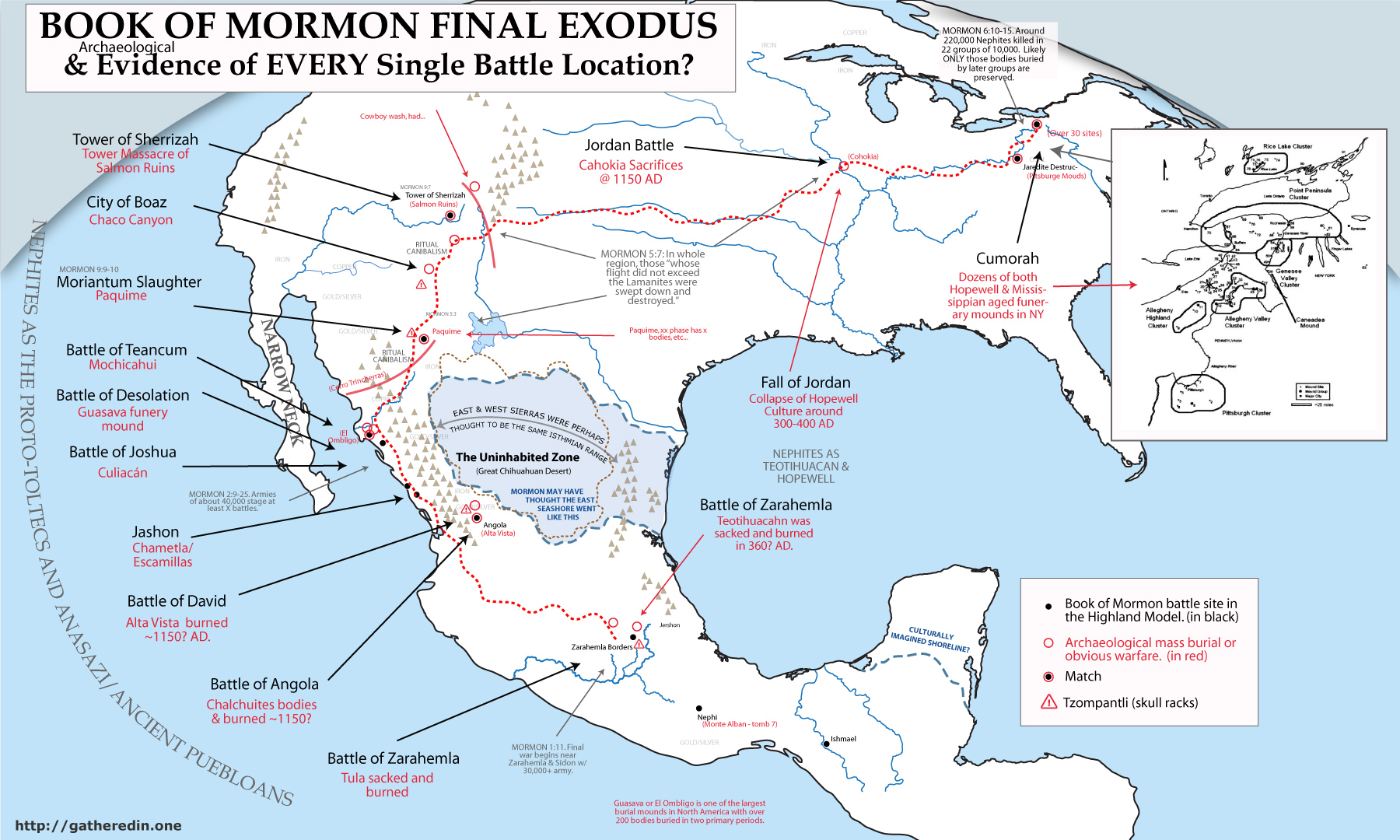
The Collapse of Classic Ancient American Civilization
The peace was not to stay. Midway through the Classic social classes appeared again. An extravagant upper class emerged; churches began to decorate their temples with riches; idol worship commenced; mass production and long distance trade networks appeared. Gambling, tattoos, body-piercing, and drugs became vogue, enveloping society. The gods and culture of the Pre-Classic Maya returned in places and Teotihuacan responded by exercising harsh dominion. Wars spread across the land. Soon two distinct super-powers emerged: the Quetzalcoatl Cult centered at Teotihuacan and the Jaguar Cult of southern Yucatan. Mayan frescos paint the conflicts. In Maya lands they portray early local victories. As the Jaguar Cult grew in numbers and power they began conquering Central Mexico: at Xochicalco archaeologists have found a mural depicting the Eagle Warriors of the Jaguar Cult crushing the feathered serpent, Quetzalcoatl. It dates to just before Teotihuacan was abandoned.
War moved in succession from Teotihuacan to the Chichimec lands, to the coast of West Mexico, then north across a ‘narrow ecological strip’ in the Sierra Madre Occidental to the Southwest. The amazing burst of economic activity in the Anasazi lands followed, corresponding with the build-up of the Toltec Kingdom and the evacuation of the upper class in Maya lands. Then came the great slaughter. Starting in the south and moving north the entire Southwest was desolated. Smaller sites were abandoned and great defensive cities were built but to no avail. Archaeologists find site after site burnt, abandoned, or covered with unburied bodies. The destruction is staggering. It moved to a line of sites from Mesa Verde, Colorado to Albuquerque, New Mexico but then these too were abandoned. Then the entire Midwest was abandoned and the Mississippian culture collapsed.
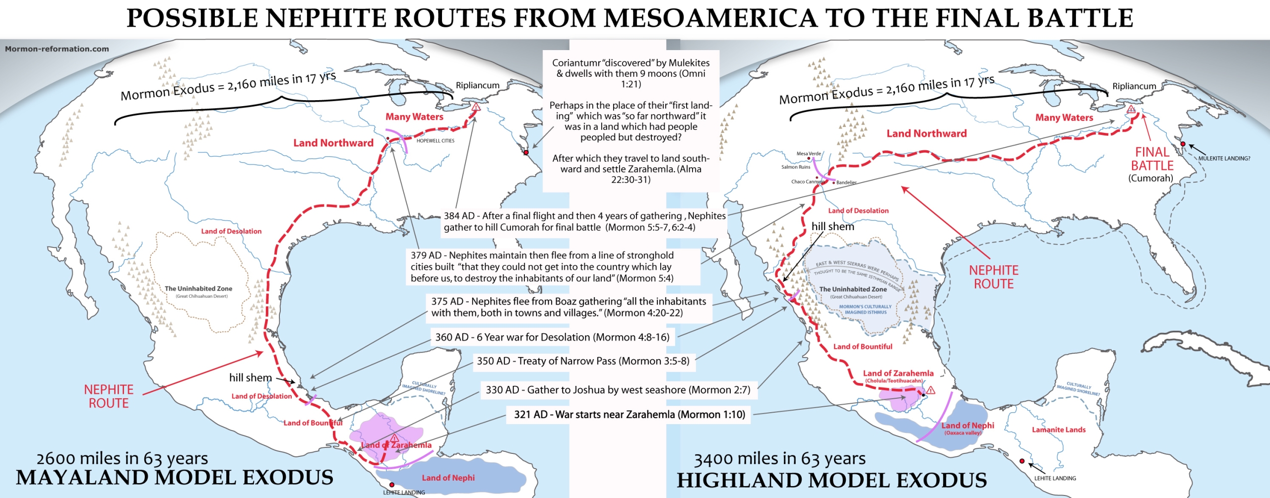
Archaeologists are at a loss to explain why these cultures collapsed. Drought is a common (but poor) explanation, but evidence of war is present although often ignored or explained away. We believe the social fabric of these cultures was destroyed as the Lamanite armies chased the Nephites from the Valley of Mexico, to the American Southwest, and finally up the Ohio arm of the Mississippi (the main travel corridor) to its end in the Land of Cumorah in Western New York.
The Land of Cumorah and the Final Battle
This paper might be one of the best I’ve found so far in mapping funerary mound complexes in New England. Note carefully in the text where it talks about skull fragments being common in the Allegeny complex area, and Adena Points being common in the Pittsburgh mound cluster. (Likely the Jaredite battle was in the Pittsburgh area?). Be sure to talk about how radiocarbon dates in the east vary in older or newer dates depending on the way the weather patterns came. If they came from the pacific, the dates would be diluted like the Anasazi, but if they came from the gulf or Atlantic, they’d be more accurate. So just like the mayanlands we get bimodal dates. (this will be proven or disproven by the presence of ‘anomalous’ dates and sequences in sites known to have many layers inhabited over long periods.
The Caneadea Mound: A Look At The Middle Woodland Period In The Northeast by Steven Paul Howard ….. https://etd.ohiolink.edu/apexprod/rws_etd/send_file/send?accession=osu1419266234&disposition=inline
-should hold that the actual final battle scene, much like the part of Zarahemla under the ash, is being held in reserve to be found only after the end of the times of the gentiles.
Under Construction:
Summary of strong evidences for the Continental Geographic Model correlation:
-It is the ONLY model that closely matches with the view of Joseph Smith & other contemporary early LDS leaders.
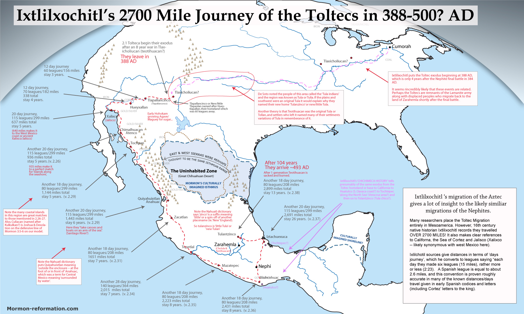
– It is really the only model which matches well with early Spanish chronologist like Ixtlilxochitl, which place the Mexican Highland (especially the Cholula region) as the place of Quetzalcoatl’s coming as well as the place of the mythical seven caverns, and golden culture of Tollan.
- Beginning of Egyptian style hieroglyphic writing and stone pyramids to replace the mounds and early Olmec script. 2. Monte Alban and its two room temple, alter, towers overlooking neighboring lands, new religious social structure, division of the valley, 3. Cholula/Teotihuacan/Tula matching Zarahemla as the most populous and influential population center in North America. 4a. Destructions4. The destruction of every major culture on the continent.
-mammoths and ‘ate them all’.
-Monte Alban 1. Earliest writing, 2. Social stratification. 3. Two room temple and alters, 4. Tower that could see an adjoining kingdom 5. Prison.
-Cholula. A great match for Zarahemla. 1. Largest temple complex on Earth. And one of the largest cities of pre-Aztec Mesoamerica. 2. Many ancient codices name it as the place of the seven caverns and the birth place of the Tolteca or Mesoamerican mother culture. 3. A suburb is still to this day called Zerexotla (Zera-hem-la vs. Zere-xot-la) 4. Eruption of Popocatepetl around the time of Christ buried the nearby city of Tetimpa in Ash, and thus very likely could have set fire to Cholula, and been part of the impetus for the growth of Teotihuacán. 5. It is just east of our River Sidon (rio Balsas), and the hill/volcan Malinche makes a perfect setting for hill –Amnu–? 6. The book of Mormon consistently refers to the LAND of Zarahemla as ‘down’, but NEVER refers to the city of Zarahemla as down (in fact says ‘up’ to the city, matching perfectly as Cholula is the population center on the edge of the Balsas Basin where many corn was domesticated.
-PROMBLEMS WITH RADIOCARBON DATING. 775 AD event. Marine reservoir exchange. https://en.wikipedia.org/wiki/774%E2%80%93775_carbon-14_spike
Great paper on it found here. https://agupubs.onlinelibrary.wiley.com/doi/full/10.1002/2017GL074208
Tree ring dating. (Find references here https://creation.com/evidence-for-multiple-ring-growth-per-year-in-bristlecone-pines)
(see txt file ‘anomalous old c14 dates in archaeology papers folder in drive)
-Caractors Document and Fernando Ixtlalapa are amazing proofs of BOM. But only prove my model a bit, so maybe put those at end? (
Main complex of Teotihuacan. The Nephite capital after Lachoneus moved it circa 17 AD.