This section presents the Book of Mormon archaeology Continental Model. Laid out to me through many inspiring dreams, visions and research.
Given the infighting and lack of consensus concerning archeological and geographical evidence for the Book of Mormon, I certainly don’t blame those who dismiss the text as just another spiritualist channeling without a solid basis in history. I’d likely be in the same boat were it not for the unique experiences I’ve had with the text, which laid out its truth and this completely unique model. Before the Spirit showed me this model, I’d found that the existing popular models out there seemed to fall a bit short of the overall ‘sea to sea’ (Hel 3:8–16) continental picture painted in the internal model of the Book of Mormon (as I’ve delineated in this article). However, this unique continental geography model overcomes those limiting issues as it essentially matches every major Book of Mormon city and culture with essentially the biggest and most influential archaeological sites, cultures, migrations and societal collapses on the ancient North American continent (in the way agreeing with what the book seems to portray). Its also the ONLY model that truly aligns with both Heartland & Mesoamerican areas of quotes we have concerning Joseph Smith’s continental model. It also explains many of the cultural anachronisms, 19th century religious overtones, and KJV biblical quotes by comparing the translation process to other forms of spiritual mediumship used by a few other inspired American religious works of the 1800’s. (See Oahspe, Urantia Bible, or the other texts featured in my channeled texts section. Also see the Kolbrin and Ixtlilxochitl’s translations of Aztec Codices for truly amazing analogs to the Book of Mormon translation).
With this view of Book of Mormon archaeology the text just seems to ‘fit’ with many of the most obvious and significant cultural events in the archaeological record. Things such as the appearance of hieroglyphic-like writing, Egyptian-like pyramids, east-facing two columned temples or the rise of the continents largest empire Teotihuacan. As well as Heartland DNA, mound builders and the sequential collapse of essentially EVERY major culture on the continent. (Mixtec, Teotihuacano, Hohokam & Hopewell and even possibly the Toltec, Chichimec, Ancestral Puebloan/Anasazi, Cahokia and Early Mississippian cultures around the alternate radiocarbon dates of 1050-1150 AD.)
This model suggests that most secular and LDS scholars have overlooked many of these surprising correlations because of misunderstandings of two simple textual concepts. . The first being the narrow neck problem, and the second being a chronology issue. Both these issues I explain at length in the following articles; giving two possible explanations on why a few of the Book of Mormon event dates might not match exactly with the radiocarbon dates in the early Jaredite and post-Christ timelines. One being a timeline lacuna/gap by Book of Mormon authors and the other being a possible needed radiocarbon date correction because of the excess radiocarbon marine reservoir effect caused by a massive comet and/or CME hitting the Pacific Ocean around the start of the Christian era. (much like the smaller documented 774 AD event)
And now, if there are faults they are the mistakes of men; wherefore, condemn not the things of God -Title page/Mormon 8:17
Featured Articles:
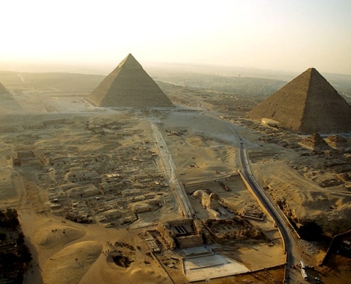 https://gatheredin.one/wp-content/uploads/2023/07/Great-Pyramids-of-Giza-Aerial-View-Cairo-Egypt.jpg
480
640
MormonBox
https://gatheredin.one/wp-content/uploads/2024/04/newest-logo-lds-temple.png
MormonBox2023-07-26 10:15:222024-03-27 14:19:31Egyptian Chronology Resources
https://gatheredin.one/wp-content/uploads/2023/07/Great-Pyramids-of-Giza-Aerial-View-Cairo-Egypt.jpg
480
640
MormonBox
https://gatheredin.one/wp-content/uploads/2024/04/newest-logo-lds-temple.png
MormonBox2023-07-26 10:15:222024-03-27 14:19:31Egyptian Chronology Resources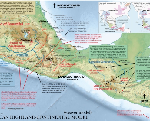 https://gatheredin.one/wp-content/uploads/2017/01/bom-continental-model-on-relief.jpg
1170
1740
MormonBox
https://gatheredin.one/wp-content/uploads/2024/04/newest-logo-lds-temple.png
MormonBox2022-04-11 14:48:362024-03-28 07:44:55Book of Mormon Geography Found- Mexican Highland Continental Model (summary)
https://gatheredin.one/wp-content/uploads/2017/01/bom-continental-model-on-relief.jpg
1170
1740
MormonBox
https://gatheredin.one/wp-content/uploads/2024/04/newest-logo-lds-temple.png
MormonBox2022-04-11 14:48:362024-03-28 07:44:55Book of Mormon Geography Found- Mexican Highland Continental Model (summary)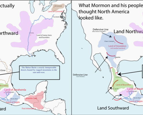 https://gatheredin.one/wp-content/uploads/2018/03/Book-of-Mormon-Geography-what-Mormon-thought.jpg
800
1702
MormonBox
https://gatheredin.one/wp-content/uploads/2024/04/newest-logo-lds-temple.png
MormonBox2018-03-06 10:45:052023-08-18 23:35:07The Mexican Highland-Continental Book of Mormon Geography Model (book drafts)
https://gatheredin.one/wp-content/uploads/2018/03/Book-of-Mormon-Geography-what-Mormon-thought.jpg
800
1702
MormonBox
https://gatheredin.one/wp-content/uploads/2024/04/newest-logo-lds-temple.png
MormonBox2018-03-06 10:45:052023-08-18 23:35:07The Mexican Highland-Continental Book of Mormon Geography Model (book drafts)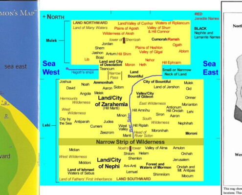 https://gatheredin.one/wp-content/uploads/2016/05/internal-models-bom.jpg
700
1710
MormonBox
https://gatheredin.one/wp-content/uploads/2024/04/newest-logo-lds-temple.png
MormonBox2012-03-03 10:51:002024-04-21 13:00:56Book of Mormon Geography: An Internal Model
https://gatheredin.one/wp-content/uploads/2016/05/internal-models-bom.jpg
700
1710
MormonBox
https://gatheredin.one/wp-content/uploads/2024/04/newest-logo-lds-temple.png
MormonBox2012-03-03 10:51:002024-04-21 13:00:56Book of Mormon Geography: An Internal ModelNorth American Archaeology Explorer
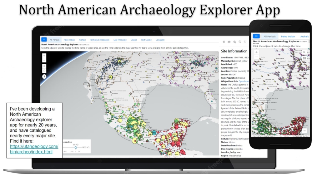 Use this interactive Map to explorer the archaeological sights on North America. This map draws from an extensive database of North American Meso-american and Paleo-Indian sights. Slide the time-slider to animate the map showing sites as they are settled and abandoned.
Book of Mormon Archaeology Story Map
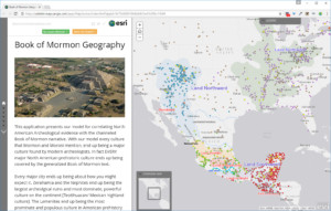
This application is still under construction. It dynamically walks the user through the Book of Mormon Narrative using an interactive map application which show both archaeological sites as well as their Book of Mormon analogs. Simply click the arrows to advance through the tabs and images to understand how current archaeological findings correlate with the Book of Mormon narrative. (old version)
 https://gatheredin.one/wp-content/uploads/2022/08/urim.jpg
291
400
MormonBox
https://gatheredin.one/wp-content/uploads/2024/04/newest-logo-lds-temple.png
MormonBox2022-08-19 08:54:492024-04-20 05:27:06Understanding the Translation Process: Did Joseph Smith use the Urim and Thummim & Gold Plates or Rock in a Hat? (And why the 116 pages weren’t retranslated)
https://gatheredin.one/wp-content/uploads/2022/08/urim.jpg
291
400
MormonBox
https://gatheredin.one/wp-content/uploads/2024/04/newest-logo-lds-temple.png
MormonBox2022-08-19 08:54:492024-04-20 05:27:06Understanding the Translation Process: Did Joseph Smith use the Urim and Thummim & Gold Plates or Rock in a Hat? (And why the 116 pages weren’t retranslated)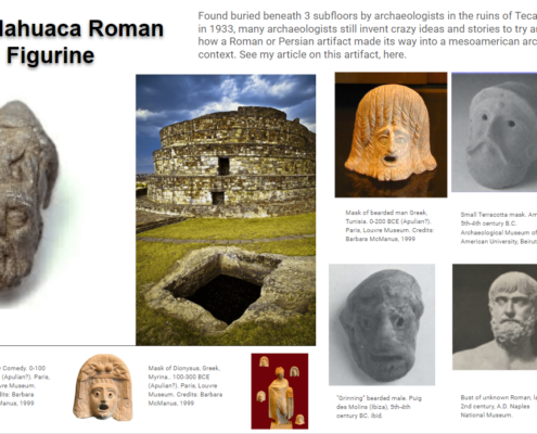 https://gatheredin.one/wp-content/uploads/2022/08/image.png
695
1238
MormonBox
https://gatheredin.one/wp-content/uploads/2024/04/newest-logo-lds-temple.png
MormonBox2022-08-18 19:20:432022-08-19 16:32:08The Calixtlahuaca Roman Figurine: Evidence of Transoceanic travel to Mesoamerica.
https://gatheredin.one/wp-content/uploads/2022/08/image.png
695
1238
MormonBox
https://gatheredin.one/wp-content/uploads/2024/04/newest-logo-lds-temple.png
MormonBox2022-08-18 19:20:432022-08-19 16:32:08The Calixtlahuaca Roman Figurine: Evidence of Transoceanic travel to Mesoamerica. https://gatheredin.one/wp-content/uploads/2022/03/book-of-mormon-timeline.jpg
424
835
MormonBox
https://gatheredin.one/wp-content/uploads/2024/04/newest-logo-lds-temple.png
MormonBox2022-03-23 23:11:362022-04-12 14:18:43Book of Mormon Exhaustive Timeline
https://gatheredin.one/wp-content/uploads/2022/03/book-of-mormon-timeline.jpg
424
835
MormonBox
https://gatheredin.one/wp-content/uploads/2024/04/newest-logo-lds-temple.png
MormonBox2022-03-23 23:11:362022-04-12 14:18:43Book of Mormon Exhaustive Timeline https://gatheredin.one/wp-content/uploads/2022/03/554990e4335aa73c50f04e9ea1b380.jpeg
243
380
MormonBox
https://gatheredin.one/wp-content/uploads/2024/04/newest-logo-lds-temple.png
MormonBox2022-03-23 22:33:172022-04-12 14:21:09Mesoamerican Prehistory Timeline
https://gatheredin.one/wp-content/uploads/2022/03/554990e4335aa73c50f04e9ea1b380.jpeg
243
380
MormonBox
https://gatheredin.one/wp-content/uploads/2024/04/newest-logo-lds-temple.png
MormonBox2022-03-23 22:33:172022-04-12 14:21:09Mesoamerican Prehistory Timeline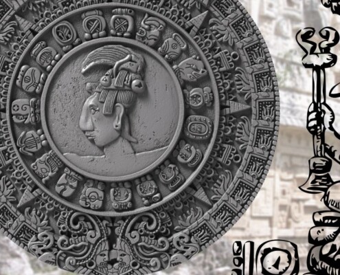 https://gatheredin.one/wp-content/uploads/2021/01/mesoamerican-mayan-calendar-1.jpg
602
1220
MormonBox
https://gatheredin.one/wp-content/uploads/2024/04/newest-logo-lds-temple.png
MormonBox2021-01-25 12:04:242024-05-14 09:39:23The Aztec/Mayan Calendar (And its similarities to the Hebrew/Biblical Calendar & Book of Mormon dates)
https://gatheredin.one/wp-content/uploads/2021/01/mesoamerican-mayan-calendar-1.jpg
602
1220
MormonBox
https://gatheredin.one/wp-content/uploads/2024/04/newest-logo-lds-temple.png
MormonBox2021-01-25 12:04:242024-05-14 09:39:23The Aztec/Mayan Calendar (And its similarities to the Hebrew/Biblical Calendar & Book of Mormon dates)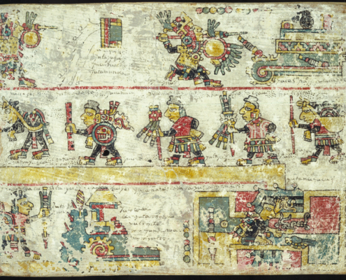 https://gatheredin.one/wp-content/uploads/2021/01/codex-colombino.jpg
711
1250
MormonBox
https://gatheredin.one/wp-content/uploads/2024/04/newest-logo-lds-temple.png
MormonBox2021-01-11 17:31:372023-08-10 10:26:26Ixtlilxochitl & Evidence for the Book of Mormon in Mesoamerican Codices
https://gatheredin.one/wp-content/uploads/2021/01/codex-colombino.jpg
711
1250
MormonBox
https://gatheredin.one/wp-content/uploads/2024/04/newest-logo-lds-temple.png
MormonBox2021-01-11 17:31:372023-08-10 10:26:26Ixtlilxochitl & Evidence for the Book of Mormon in Mesoamerican Codices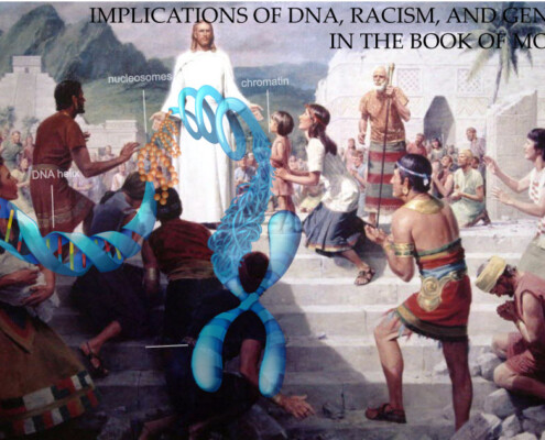 https://gatheredin.one/wp-content/uploads/2020/12/dna-and-race-in-book-of-mormon.jpg
632
1024
MormonBox
https://gatheredin.one/wp-content/uploads/2024/04/newest-logo-lds-temple.png
MormonBox2020-12-29 21:44:322023-04-10 11:21:31Oh ye fair ones: The implications of racism and genocide on Book of Mormon DNA evidence
https://gatheredin.one/wp-content/uploads/2020/12/dna-and-race-in-book-of-mormon.jpg
632
1024
MormonBox
https://gatheredin.one/wp-content/uploads/2024/04/newest-logo-lds-temple.png
MormonBox2020-12-29 21:44:322023-04-10 11:21:31Oh ye fair ones: The implications of racism and genocide on Book of Mormon DNA evidence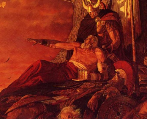 https://gatheredin.one/wp-content/uploads/2018/08/destruction.jpg
600
800
MormonBox
https://gatheredin.one/wp-content/uploads/2024/04/newest-logo-lds-temple.png
MormonBox2018-08-15 13:59:202023-10-09 11:08:50Were the Book of Mormon Nephites actually Toltecs & Anasazi? Evidence for the Final Exodus and Battles
https://gatheredin.one/wp-content/uploads/2018/08/destruction.jpg
600
800
MormonBox
https://gatheredin.one/wp-content/uploads/2024/04/newest-logo-lds-temple.png
MormonBox2018-08-15 13:59:202023-10-09 11:08:50Were the Book of Mormon Nephites actually Toltecs & Anasazi? Evidence for the Final Exodus and Battles https://gatheredin.one/wp-content/uploads/2018/03/book-of-mormon-and-seer-stone-1.jpg
360
833
MormonBox
https://gatheredin.one/wp-content/uploads/2024/04/newest-logo-lds-temple.png
MormonBox2018-03-07 13:06:412022-04-06 18:20:29Arguments For and Against the Authenticity of the Book of Mormon
https://gatheredin.one/wp-content/uploads/2018/03/book-of-mormon-and-seer-stone-1.jpg
360
833
MormonBox
https://gatheredin.one/wp-content/uploads/2024/04/newest-logo-lds-temple.png
MormonBox2018-03-07 13:06:412022-04-06 18:20:29Arguments For and Against the Authenticity of the Book of Mormon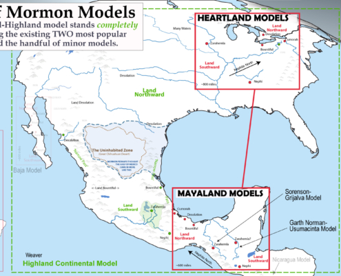 https://gatheredin.one/wp-content/uploads/2017/01/Book-of-Mormon-Geography-different-models-new.jpg
1080
1940
MormonBox
https://gatheredin.one/wp-content/uploads/2024/04/newest-logo-lds-temple.png
MormonBox2017-01-26 18:04:472024-03-27 15:36:17Comparing Book of Mormon Geography Models
https://gatheredin.one/wp-content/uploads/2017/01/Book-of-Mormon-Geography-different-models-new.jpg
1080
1940
MormonBox
https://gatheredin.one/wp-content/uploads/2024/04/newest-logo-lds-temple.png
MormonBox2017-01-26 18:04:472024-03-27 15:36:17Comparing Book of Mormon Geography Models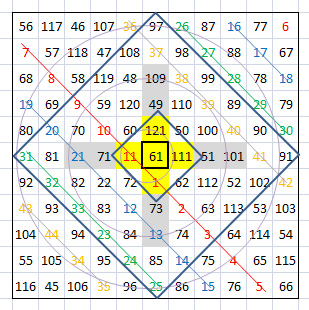 https://gatheredin.one/wp-content/uploads/2010/06/magic-square.jpg
310
309
MormonBox
https://gatheredin.one/wp-content/uploads/2024/04/newest-logo-lds-temple.png
MormonBox2016-09-14 07:40:382016-09-14 07:46:16Making Sense of the Numbers of Genesis
https://gatheredin.one/wp-content/uploads/2010/06/magic-square.jpg
310
309
MormonBox
https://gatheredin.one/wp-content/uploads/2024/04/newest-logo-lds-temple.png
MormonBox2016-09-14 07:40:382016-09-14 07:46:16Making Sense of the Numbers of Genesis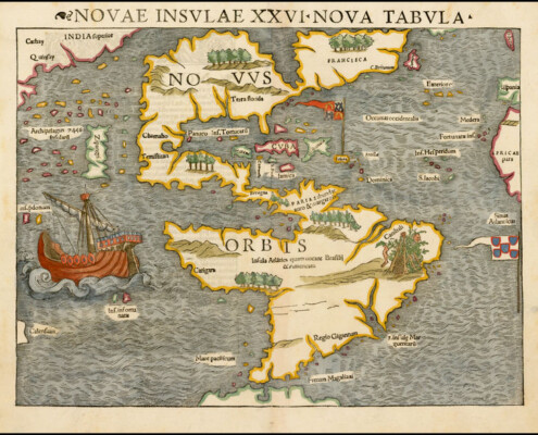 https://gatheredin.one/wp-content/uploads/2016/05/early_north_america_map2.jpg
589
750
MormonBox
https://gatheredin.one/wp-content/uploads/2024/04/newest-logo-lds-temple.png
MormonBox2016-05-04 09:18:322023-09-27 07:50:00The Narrow Neck as Baja and the Sea of Cortez
https://gatheredin.one/wp-content/uploads/2016/05/early_north_america_map2.jpg
589
750
MormonBox
https://gatheredin.one/wp-content/uploads/2024/04/newest-logo-lds-temple.png
MormonBox2016-05-04 09:18:322023-09-27 07:50:00The Narrow Neck as Baja and the Sea of Cortez https://gatheredin.one/wp-content/uploads/2023/08/image-3.png
768
1379
MormonBox
https://gatheredin.one/wp-content/uploads/2024/04/newest-logo-lds-temple.png
MormonBox2015-06-16 15:13:002023-09-01 13:08:20Q&A: Questions and Answers to Debatable Book of Mormon Geography Topics
https://gatheredin.one/wp-content/uploads/2023/08/image-3.png
768
1379
MormonBox
https://gatheredin.one/wp-content/uploads/2024/04/newest-logo-lds-temple.png
MormonBox2015-06-16 15:13:002023-09-01 13:08:20Q&A: Questions and Answers to Debatable Book of Mormon Geography Topics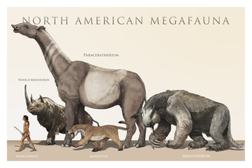 https://gatheredin.one/wp-content/uploads/2013/06/north-american-megafauna.jpg
1000
1500
MormonBox
https://gatheredin.one/wp-content/uploads/2024/04/newest-logo-lds-temple.png
MormonBox2015-06-12 16:05:002023-10-04 18:27:41Animals in the Book of Mormon
https://gatheredin.one/wp-content/uploads/2013/06/north-american-megafauna.jpg
1000
1500
MormonBox
https://gatheredin.one/wp-content/uploads/2024/04/newest-logo-lds-temple.png
MormonBox2015-06-12 16:05:002023-10-04 18:27:41Animals in the Book of Mormon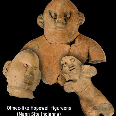 https://gatheredin.one/wp-content/uploads/2014/08/mann_site_hopewell_figureens.jpg
443
400
MormonBox
https://gatheredin.one/wp-content/uploads/2024/04/newest-logo-lds-temple.png
MormonBox2014-08-14 12:34:062023-09-28 15:21:47MesoAmerican/Mayan influence on Mississippian Culture
https://gatheredin.one/wp-content/uploads/2014/08/mann_site_hopewell_figureens.jpg
443
400
MormonBox
https://gatheredin.one/wp-content/uploads/2024/04/newest-logo-lds-temple.png
MormonBox2014-08-14 12:34:062023-09-28 15:21:47MesoAmerican/Mayan influence on Mississippian Culture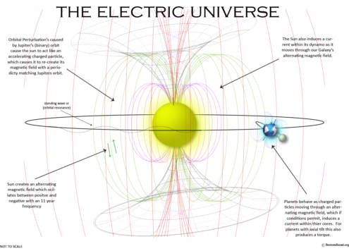 https://gatheredin.one/wp-content/uploads/2014/06/Electric-universe-e1402606735395.png
978
1359
MormonBox
https://gatheredin.one/wp-content/uploads/2024/04/newest-logo-lds-temple.png
MormonBox2014-06-04 11:07:012023-07-31 14:25:03Multi-dimensionality and the relativity of fundamental units in physics
https://gatheredin.one/wp-content/uploads/2014/06/Electric-universe-e1402606735395.png
978
1359
MormonBox
https://gatheredin.one/wp-content/uploads/2024/04/newest-logo-lds-temple.png
MormonBox2014-06-04 11:07:012023-07-31 14:25:03Multi-dimensionality and the relativity of fundamental units in physics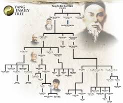 https://gatheredin.one/wp-content/uploads/2010/07/family-tree.jpg
205
246
MormonBox
https://gatheredin.one/wp-content/uploads/2024/04/newest-logo-lds-temple.png
MormonBox2014-05-29 20:41:002023-01-26 09:08:24Bible Chronology / Timeline from Adam to Zedekiah
https://gatheredin.one/wp-content/uploads/2010/07/family-tree.jpg
205
246
MormonBox
https://gatheredin.one/wp-content/uploads/2024/04/newest-logo-lds-temple.png
MormonBox2014-05-29 20:41:002023-01-26 09:08:24Bible Chronology / Timeline from Adam to Zedekiah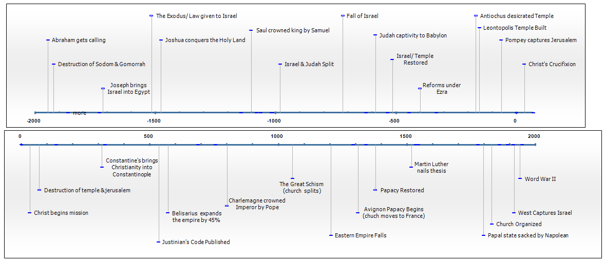 https://gatheredin.one/wp-content/uploads/2010/11/history-correlation-chart.png
513
1176
MormonBox
https://gatheredin.one/wp-content/uploads/2024/04/newest-logo-lds-temple.png
MormonBox2014-05-28 10:26:392023-01-27 19:35:37Book of Mormon Chronology: Jaredite Timeline
https://gatheredin.one/wp-content/uploads/2010/11/history-correlation-chart.png
513
1176
MormonBox
https://gatheredin.one/wp-content/uploads/2024/04/newest-logo-lds-temple.png
MormonBox2014-05-28 10:26:392023-01-27 19:35:37Book of Mormon Chronology: Jaredite Timeline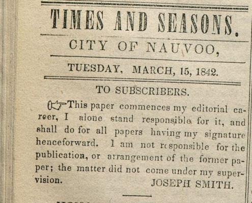 https://gatheredin.one/wp-content/uploads/2012/07/js-time-seasons-quote.jpg
581
682
MormonBox
https://gatheredin.one/wp-content/uploads/2024/04/newest-logo-lds-temple.png
MormonBox2012-07-22 18:45:002024-03-25 20:29:25Joseph Smith Quotes on Book of Mormon Geography
https://gatheredin.one/wp-content/uploads/2012/07/js-time-seasons-quote.jpg
581
682
MormonBox
https://gatheredin.one/wp-content/uploads/2024/04/newest-logo-lds-temple.png
MormonBox2012-07-22 18:45:002024-03-25 20:29:25Joseph Smith Quotes on Book of Mormon Geography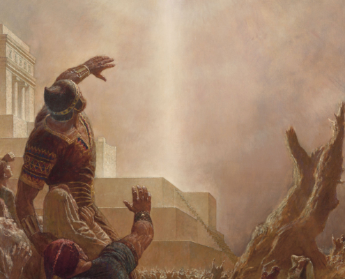 https://gatheredin.one/wp-content/uploads/2011/07/christ-nephites.jpg
2306
1600
MormonBox
https://gatheredin.one/wp-content/uploads/2024/04/newest-logo-lds-temple.png
MormonBox2011-07-27 17:04:002023-10-02 11:46:46Accounts of Destructions & Darkness at Christs Death from Around the World
https://gatheredin.one/wp-content/uploads/2011/07/christ-nephites.jpg
2306
1600
MormonBox
https://gatheredin.one/wp-content/uploads/2024/04/newest-logo-lds-temple.png
MormonBox2011-07-27 17:04:002023-10-02 11:46:46Accounts of Destructions & Darkness at Christs Death from Around the World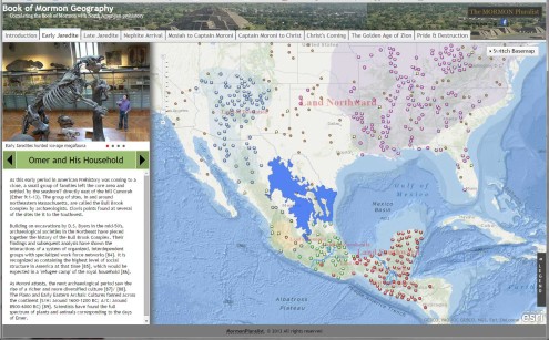 https://gatheredin.one/wp-content/uploads/2010/06/book-mormon-archeology-map.jpg
946
1524
T.W.
https://gatheredin.one/wp-content/uploads/2024/04/newest-logo-lds-temple.png
T.W.2011-02-23 17:48:082023-10-23 18:22:02Book of Mormon Archeology Unearthed
https://gatheredin.one/wp-content/uploads/2010/06/book-mormon-archeology-map.jpg
946
1524
T.W.
https://gatheredin.one/wp-content/uploads/2024/04/newest-logo-lds-temple.png
T.W.2011-02-23 17:48:082023-10-23 18:22:02Book of Mormon Archeology Unearthed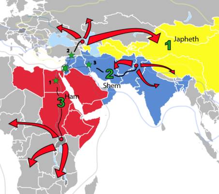 https://gatheredin.one/wp-content/uploads/2010/11/scat-israel-in-ham-shem-japeth.png
646
732
MormonBox
https://gatheredin.one/wp-content/uploads/2024/04/newest-logo-lds-temple.png
MormonBox2010-11-22 12:49:282023-02-11 14:55:08The Scattering and Gathering of Israel (Jacob 5)
https://gatheredin.one/wp-content/uploads/2010/11/scat-israel-in-ham-shem-japeth.png
646
732
MormonBox
https://gatheredin.one/wp-content/uploads/2024/04/newest-logo-lds-temple.png
MormonBox2010-11-22 12:49:282023-02-11 14:55:08The Scattering and Gathering of Israel (Jacob 5)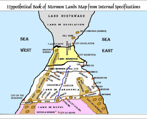 https://gatheredin.one/wp-content/uploads/2010/07/book-mormon-geography.jpg
743
988
MormonBox
https://gatheredin.one/wp-content/uploads/2024/04/newest-logo-lds-temple.png
MormonBox2010-07-22 16:37:012015-04-07 13:35:00Book of Mormon Geography Scriptures
https://gatheredin.one/wp-content/uploads/2010/07/book-mormon-geography.jpg
743
988
MormonBox
https://gatheredin.one/wp-content/uploads/2024/04/newest-logo-lds-temple.png
MormonBox2010-07-22 16:37:012015-04-07 13:35:00Book of Mormon Geography Scriptures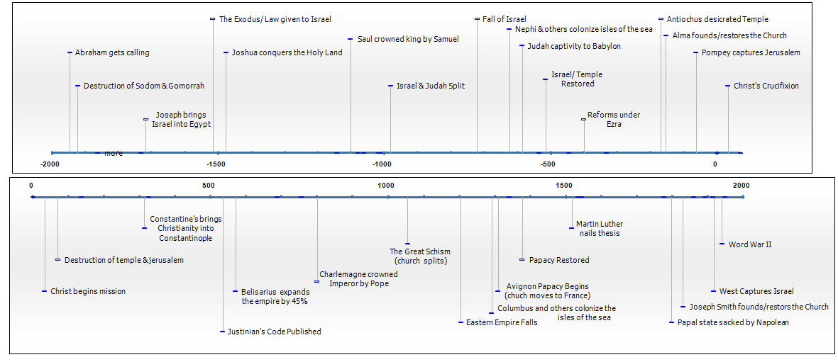 https://gatheredin.one/wp-content/uploads/2010/11/history-correlation-chart1.png
511
1181
MormonBox
https://gatheredin.one/wp-content/uploads/2024/04/newest-logo-lds-temple.png
MormonBox2010-07-22 16:28:112023-09-14 08:50:17Scientific vs. Scriptural Timelines
https://gatheredin.one/wp-content/uploads/2010/11/history-correlation-chart1.png
511
1181
MormonBox
https://gatheredin.one/wp-content/uploads/2024/04/newest-logo-lds-temple.png
MormonBox2010-07-22 16:28:112023-09-14 08:50:17Scientific vs. Scriptural Timelines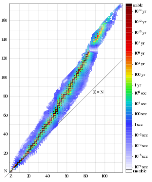 https://gatheredin.one/wp-content/uploads/2010/07/element-stability.png
360
300
MormonBox
https://gatheredin.one/wp-content/uploads/2024/04/newest-logo-lds-temple.png
MormonBox2010-07-22 10:57:542016-09-21 12:56:16Protected: Correlations Between Scriptural & Radiometric Dates.
https://gatheredin.one/wp-content/uploads/2010/07/element-stability.png
360
300
MormonBox
https://gatheredin.one/wp-content/uploads/2024/04/newest-logo-lds-temple.png
MormonBox2010-07-22 10:57:542016-09-21 12:56:16Protected: Correlations Between Scriptural & Radiometric Dates. https://gatheredin.one/wp-content/uploads/2014/08/The-Book-of-Mormon-e1448295426380.jpg
794
943
MormonBox
https://gatheredin.one/wp-content/uploads/2024/04/newest-logo-lds-temple.png
MormonBox2010-02-20 10:31:002022-08-31 09:32:45Book of Mormon Geography Scriptures & Notes
https://gatheredin.one/wp-content/uploads/2014/08/The-Book-of-Mormon-e1448295426380.jpg
794
943
MormonBox
https://gatheredin.one/wp-content/uploads/2024/04/newest-logo-lds-temple.png
MormonBox2010-02-20 10:31:002022-08-31 09:32:45Book of Mormon Geography Scriptures & Notes